
Soil & Groundwater Product Alerts
|
|
Soil & Groundwater Product Alerts |
 |
|---|
| New and recently updated products & services |
|---|
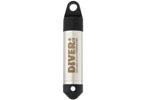 |
Groundwater Dataloggers - Micro-Diver
By Schlumberger Water Service Groundwater monitoring instruments that set the standard for reliability and longevity in data acquistions. The Micro-Diver is the most compact groundwater datalogger in its class. Small in size, large in achievement. Micro-Diver is an extremely accurate, automated monitoring instrument to measure groundwater level and temperature, with date and timesimply and reliably. Its compact design and substantial internal memory makes it an ideal choice for monitoring wells ... Request More Information | ||||
 |
The Biological Degradation
By BIOCONSULTING and Engineering Service, S.L. (BIOCONS) Due to their high elimination performance and cost-efficiency, the biological treatment of substrates (effluent, waste gas and sludges), is among the most widely-applied processes. Request More Information | ||||
| |||||
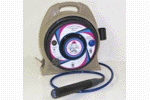 |
Spill BuddyTM
By Clean Earth Technology, Inc. The Spill Buddy is a compact, manual, free product skimming system, designed to operate on site to skim quantities of product (LNAPL or DNAPL). The Spill Buddy`s operation is based on the state-of-the-art ALPHA-ARRAY sensors in the probe that detect the interface between the product and the water. An audible feedback signals the user to keep the pump positioned in the product layer, and allows product skimming with virtually no water pumped (dependent on operator`s ... Request More Information Download Brochure | ||||
 |
COOLPRO®
By Cooley Group Coolpro polypropylene geomebranes excel under some of the most demanding conditions on earth. Coolpro meets and exceeds the critical challenges of liquid containment and pollution control. Request More Information Download Brochure | ||||
 |
GEPlotNet
By Enviroware s.r.l. GEPlotNet is a handy application designed for plotting contours and grids in KML (Keyhole Markup Language) format for Google Earth. GEPlotNet can be used to create plots of concentration, deposition, orography, land use, and many other variables representable as 2D maps. GEPlotNet is a software program for the environmental and geosciences, fast, efficient, and easy to use, which runs on Windows PCs. Request More Information Download Brochure | ||||
|
Advertise in this Newsletter For information on advertising in this newsletter, contact us or call USA 1-888-244-5029 / Europe +34 91 395 2971. © 2009 Environmental Expert S.L. |
