We compiled all our current information on flood prevention and flood warning for you. This central resource library contains webinar recordings, white papers, and practical selection guides, so you are always well prepared.
Assessment levels for Soil and Sediment in Western Australia were adopted by the Department of Environment and Conservation (DEC) to provide measures which are used in determining whether sites are contaminated. The assessment covers substances which threaten human health and the environment. It is ...
WinSism run under Windows 32 and 64. WinSism is your Windows solutions to process Seismic refraction. The software is user friendly and can be used very intuitively. With WinSism you can display SEG-2, SEG-Y, ABEM, OYO, PASI and Geometrics records. first break picking is very easy and precise on the screen. On screen corrections are possible for FBP. After your enter field geometry, travel time assembly takes few seconds and data can be corrected on a build-in spreadsheet. Shots and receivers can have any geometry and elevations. All data are recorded in an ASCII file (maximum 200 receivers and 50 shots).
Determining the availability and quality of groundwater has become an issue for an increasing number of businesses and government agencies. Changes in legislation, pressure on aquifer supplies and a heightened awareness of the impact of industrial activity have made groundwater sampling a hot topic. ...
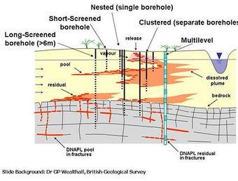
Geotechnical Borehole LoggingGeotechnical borehole logging involves the use of boreholes to perform investigations on materials from deep underground for geotechnical designs. The approach is applied for obtaining information on ground movements, groundwater levels, material strengths, permeability, ...
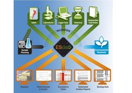
EarthSoft has more than two decades of experience in developing technology solutions to manage environmental data throughout a project lifecycle from ...
Kunming City, Yunnan Province, China
Ecological Laboratories authorized representatives from the United States presented a program for biological remediation ...
The aim of this course is to provide both a solid theoretical understanding and a comprehensive practical introduction to the use of geographic information systems and remote sensing technologies for the analysis and solution of different water and environmental problems.
Test out your GIS knowledge and skill with hands-on GIS software application! With a focus on layout and core functionality, this 12-hour online evening course offers an overview of basic GIS and spatial analysis concepts, spatial data types and searching for geographic data, ArcGIS Pro components, ...
Princeton Groundwater`s Remediation Course is the most comprehensive course on remediation available. It is taught twice a year in the spring (typically May) in Las Vegas and in the fall (typically October/November) in Miami. During ...
The SGEM Vienna Green 2020 Conference is organized as an extended Scientific Sessions of the International Scientific GeoConference SGEM.
The conference will be held at one of the most historical palace buildings in Vienna - Schönbrunn ...
For information on advertising in this Newsletter, contact us or call USA 1-888-244-5029 / Europe +34 91 395 2969.