|
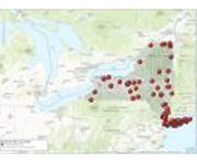
Digital borehole geophysical logs and related data files are now accessible through GeoLog Locator, a new web-based map view and retrieval tool developed by the U.S. Geological Survey.
The tool releases more than 7000 digital borehole geophysical logs at more than 1700 locations to the public — ...
|