

ADMS-Airport - Air Pollution Modelling Software
ADMS-Airport is a comprehensive modelling tool for air quality management of airports. It has many of the features of the ADMS-Urban model and includes allowance for all relevant emission sources at airports and utilises algorithms designed specifically to model dispersion from aircraft engines.
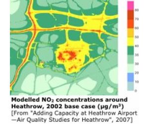
ADMS-Airport has been used to model air quality at London`s Heathrow airport for the 2002 base case and future year scenarios as part of the Department for Transport`s (DfT) Project for Sustainable Development of Heathrow (PSDH)—Adding Capacity at Heathrow.
This followed the PSDH Model Inter-comparison Study and the recommendations of the DfT`s expert panel on modelling which was in `full agreement in the recommendation of the CERC model ADMS-Airport for future modelling work at Heathrow`. ADMS-Airport continues to be used for air quality assessments at Heathrow airport (see the Heathrow Air Quality Strategy 2011).
London Gatwick Airport has used ADMS-Airport for dispersion modelling in all its recent assessment studies (see Gatwick Airport’s July 2014submission to the Airports Commission).
ADMS-Airport is also one of the approved models for the International Civil Aviation Organisation, Committee on Aviation Environmental Protection (ICAO CAEP), Models and Databases Group. The approved models create projections at all major airports worldwide that are used by the ICAO Assembly as the basis for decision making on environmental matters.
The ICAO Airport Air Quality Manual gives simple, advanced and sophisticated approaches for dispersion modelling in the vicinity of airports. ADMS-Airport is listed as a typical model used in the advanced and sophisticated approaches.
ADMS-Airport incorporates all the features of ADMS-Urban plus it is able to incorporate sources specific to an airport. ADMS-Airport is able to take into account the whole range of relevant emission sources: aircraft traffic, auxiliary power units, ground support equipment, road traffic, industrial, commercial, domestic and other less well-defined sources.
ADMS-Airport and EMIT (CERC`s Emissions Inventory Toolkit) have been developed with a number of features to simplify the modelling process and help users. For example:
- Visualisation : ADMS-Airport has links to ArcGIS and MapInfo Professional GIS (Geographical Information System) packages as well as Surfer contour plotting package. The GIS link can be used to enter and display input data and display output, usually as colour contour plots.
- Emissions inventory : Source and emissions data can be imported from a Microsoft Access database created by the user or exported from EMIT. EMIT contains current and future emission factors including those for vehicles, industrial processes and fuel consumption.
- Emission factors : (in EMIT) : Issue 15 of the ICAO emission factors (released July 2007) can be used to calculate emissions from the thrust setting, time in mode and the number of landing-take-off cycles. FAA emission factors can be used to calculate APU emissions from the operation time. Emission factors derived from EC Non Road Mobile Machinery (EC directive 97/68/EC) limit values can be used to calculate GSE emissions from the operation time. The latest UK DMRB emission factors (released February 2003) can be used to calculate emissions from traffic flows and speeds.
- Intelligent gridding : ADMS-Airport includes an intelligent gridding option which places extra output points in and adjacent to aircraft jet sources and road sources to give excellent spatial resolution in areas of particular interest.
- User-defined outputs : The user defines the pollutant and averaging time which may be an annual average or a shorter period, and also which percentiles and exceedence values to calculate, and whether a rolling average is required or not. The output options are designed to be flexible to cater for the variety of air quality limits which can vary from country to country and over time.
ADMS jet module
ADMS-Airport makes use of the ADMS jet model to calculate the impact of aircraft exhausts. The jet model calculates an integral solution to the equations of conservation of mass, momentum, heat and species, capturing the effect of the movement of the jet engine source in reducing the effective buoyancy of the exhaust. This is particularly important in capturing the near-field dispersion from the high momentum, buoyant take-off ground roll sources.
Hourly profiles
To model the airport`s flight schedule in detail users can construct up to 500 annual hourly profiles. These detailed schedules can also be used for detailed modelling of non-airport sources, such as the effect of school terms and public holidays on road traffic. For less detailed time dependent modelling ADMS-Airport allows up to 500 diurnal and 500 monthly profiles plus wind direction dependence for any source.
One of the most important advanced modules in ADMS-Airport is the chemistry module. The following options are available:
- NOx – NO2 chemistry
- The Trajectory model
- Sulphate chemistry
Other advanced modules are:
- Street canyons
- Buildings
These modules are based on the latest understanding of the way these features affect the movement of airflow around the sources, and all have been shown to have considerable affect on observed concentrations.
Chemistry moduleNOx – NO2 chemistry
ADMS-Airport models NOx chemistry using the 8 reaction Generic Reaction Set (Venkatram et al., 1994) that includes reactions with ozone and hydrocarbons.
In most urban areas, the dominant pollution source is road traffic, and the pollutants usually of major interest are NOxand PM10. The NOx chemical reactions take place over a relatively short time period and in order to get accurate predictions of NO2 concentrations, NOx chemistry should be taken into account. The Generic Reaction Set predicts changes in ozone concentrations that are also of interest.
The Trajectory model
A simple Lagrangian Trajectory Model is used to calculate background concentrations for the air approaching the main modelling area. This model includes the effects of emissions, chemistry, deposition and ozone entrainment.
By nesting the main model domain within a larger domain, such as a large urban conurbation, the Trajectory Model calculates a spatially varying background ambient concentration that takes into account the chemical reactions and processes occurring over the larger domain.
Sulphate chemistry
The reactions between SO2 and other compounds in the air to produce particulates are based on those used in the EMEPmodel (Tsyro, 2001).
These reactions have a significant effect on the concentrations of particulates in areas where there are a large number of industrial sources emitting SO2 or downwind from a large emitter of SO2.
Street canyons
`Street canyons` are defined as the deep, narrow, valley-like spaces created when a road is enclosed by tall buildings on both sides. High pollution levels are often observed in street canyons. ADMS-Urban includes two modules for modelling street canyons.
The basic street canyon module is based on the Danish Operational Street Pollution Model (OSPM, Hertel and Berkowicz, 1990, Hertel et al., 1990).
The advanced street canyon module (Hood et al., 2014) can be used if a more detailed model of the street canyon is required. It differs from the basic module in the following ways:
- The model has been formulated to consider a wider range of canyon geometries, including the effects of tall canyons and of canyon asymmetry;
- The concentrations predicted by the model vary with height within the canyon;
- Emissions may be restricted to a subset of the canyon width so that they may be specified only on road lanes and not on pedestrian areas;
- There is the option to include consideration of `network` effects, where pollutants reaching the end of one street canyon can pass into a connected canyon; and
- Concentrations both inside and outside a particular street canyon are affected when running this model option.
Buildings
Users can include the effect of up to 10 dominant buildings on point source emissions. ADMS-Airport creates an effective building for each point source from the user-defined buildings and models the re-circulating flow in the lee of the building, the cavity region, as well as the building main wake.
Emissions sources
ADMS-Airport air quality model is a comprehensive tool for managing air quality at airports. It can be used to examine emissions from 8000 sources simultaneously, including:
- Aircraft jet sources, up to 500 aircraft jet sources.
- Road traffic, over 145,000 road links (3000 road sources each with up to 50 vertices).
- Industrial sources, up to 1500 point, line, area or volume sources.
- Aggregated sources (grid source), up to 3000 grid cells can be used to model emissions from sources that are too small to define explicitly, for example, emissions from domestic housing.
Source parameters include:
- for aircraft sources, engine category, number of engines, start and end locations of the straight line along which the aircraft travels, and start and end aircraft speeds;
- source location data;
- road widths and canyon heights for road sources;
- stack heights, diameters, exit velocities, etc., for industrial sources;
- grid dimensions for aggregated emissions data.
Emissions profiles
- Up to 500 user-defined emissions profiles can be included in any modelling run to take into account the diurnal variation in traffic flows.
- Seasonal variations can also be included with up to 500 monthly profiles.
- Variation of sources with wind direction—particularly useful for airport sources—can also be modelled.
For more detailed modelling, up to 500 annual hourly profiles can also be modelled.
Meteorological data
- A variety of meteorological data can be used for input and the format required is deliberately kept very simple.
- Wind speed, wind direction and temperature are required along with cloud cover, heat flux or solar radiation.
- The meteorological pre-processor calculates the necessary boundary layer parameters from the user`s input.
- There are a variety of suppliers of meteorological data across the world. A CERC meteorological data converter can convert METAR and other NWS data to ADMS format.
Traffic flow
For road sources, the user can enter hourly speed and traffic flow data into the model and use ADMS-Airport`s built-in emission factors or, alternatively, the user can enter pre-calculated emissions data, for example emissions calculated within CERC`s Emissions Inventory Toolkit, EMIT, which includes many factors such as current and future factors for Euro standard engines.
Modelling roads in urban areas is more complex than just modelling the emissions from traffic as a line source. Both the effect of street canyons and traffic-induced turbulence are included when roads are modelled in ADMS-Airport.
Background ambient concentrations
When modelling any local emissions, it is important to include the background ambient concentrations that are advected from outside the modelling area. Background ambient concentrations can be hourly values, or if these are not available, constant values can be assumed.
Aggregated emissions
In urban areas, it is also important to include the aggregated emissions from sources that may be too small to define explicitly, but whose aggregate emissions contribute to overall pollution levels. For example, domestic emissions of NOxfrom an individual household may not be known, but the aggregated emissions could be calculated using area-wide figures for fuel consumption. In ADMS-Airport, a grid source with up to 3000 grid cells can be included in any run to represent these aggregated emissions.
Model output data
Pollution concentrations can be calculated for averaging times ranging from seconds up to years. ADMS-Airport can calculate percentiles, the number of exceedences of threshold concentrations and rolling averages. These options allow users to compare concentration results directly with appropriate limits, for example those given by the UK NAQS, US NAAQS, EU or WHO.
Model results are usually first verified by making comparisons with locally monitored data. This can be done by outputting results at receptor points corresponding to monitoring site locations. Modelled and monitored concentrations can then be compared as a time series plot.
Intelligent gridding
Results created by ADMS-Airport are often presented as colour contour plots. The intelligent gridding enables users to model a large area yet obtain high spatial resolution in areas of particular interest—in and around the roads. The ADMS-Airport contour plots are an extremely effective way of communicating results to decision makers, the public and other stakeholders.
Why do you need intelligent gridding?
Intelligent gridding gives high resolution of results where it is needed—in and around the roads. The three figures below show an area of 1.4 km2 with approximately 5-km length of roads being modelled.
- (1) shows concentration results using the intelligent gridding option, and
- (2) shows concentration results without the intelligent gridding option—this type of output is typical of other roads models that do not have the intelligent gridding option.
The model interface is designed so that the user can enter the data required for the modelling in as straightforward a way as possible.
The interface consists of several main screens. To set up a model run, the user simply works through the screens entering the relevant data or referencing external data files.
ADMS-Airport is supplied with an in-depth user guide (see the Use guides page) that details all user inputs and outputs and the modelling of airport emissions inventories in EMIT. It includes a number of step-by-step worked examples.
Full details of the technical specification of ADMS-Airport can either be found in the Technical Specifications page or on request from CERC.
An annual maintenance contract provides support for users; this includes:
- maintenance model upgrades,
- use of the helpdesk by e-mail, phone, fax or post,
- attendance at the annual user group meetings,
- access to the password-protected user area.
CERC also offer basic and advanced training.
Current versions and system requirements
- Current software versions and release dates are listed here.
- System requirements and compatibility with third-party software are described on the System requirements page.