Soil & Groundwater Product Alerts
|
|
Soil & Groundwater Product Alerts |
 |
|---|
| ›› Featured products & services that match your interests |
|---|
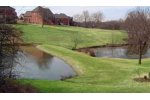 |
ArmorLoc - Effectively Control Erosion and Promote Drainage
By Contech Construction Products, Inc. ArmorLoc concrete interlocking blocks are designed to control erosion. The ArmorLoc system provides easy and economical installation when equipment is not feasible. ArmorLoc is installed manually over site-specific filter fabric on a prepared surface. Request More Information ›› Download Brochure | ||
|
| |||
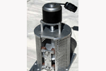 |
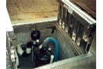
Rotapump - Model 100 - Well Head Pump with Motor and Controller
By RotaPump, Inc For convenience, ths item combines the Rotapump Model 100, Speed Controller, and 450 Watt DC Motor. Request More Information | ||
|
| |||
| |||
 |
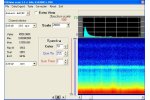
EarthImager 2D
By Advanced Geosciences, Inc. AGI EarthImager 2D is a two-dimensional resistivity and IP data interpretation software package which runs on Windows PCs. Inversion of a 2D data set often takes less than one minute. Some of its primary features include, but are not limited to, inversion of surface and borehole resistivity and IP data, Survey Planner, Time-Lapse Inversion, Continuous Resistivity Profiler (CRP), terrain correction, batch inversion, user-friendly GUI, numerous utility tools, and rapid ... Request More Information ›› Download Brochure | ||
|
| |||
 |
PEIView
By Pico Envirotec Inc. Data Viewer and Quality Control Tool Provides fast data verification for PEI binary data format files. Converts PEI binary data into ASCII format for use with standard data base programs. Converts PEI binary data into Geosoft GBN format for use with OASIS-MONTAJ data processing software. Simple data correction / editing. Magnetic compensation (compensation co-efficient files must already be created). Data import from ASCII format into PEI binary data format. Request More Information ›› Download Brochure | ||
|
| |||
 |
EQuIS for ArcGIS Server
By EarthSoft, Inc EQuIS for ArcGIS Server is an EarthSoft Enterprise, web module integrating EQuIS with ESRI's ArcGIS Server, offering full access to EQuIS Enterprise EZView. EQuIS for ArcGIS Server accesses documents and photos stored in EQuIS, spatially queries facilities for locations of all related documents, and previews documents. With EQuIS for ArcGIS, you can: Plot report output on the map Run reports with real-time data Report using Excel, PDF, KMZ, or shapefiles ... Request More Information ›› Download Brochure | ||
|
| |||
 |
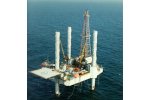
Waterwell Drill Rigs - DW320
By Sandvik Mining and Construction Sandvik DW320 is a truck-mounted, top-drive waterwell drill. This drill utilizes chassis engine for power and is designed for mud rotary drilling applications. The DW320 features quick set up at the job site and a highly efficient feed system for drilling efficiency. Request More Information | ||
|
| |||
 |
Groundwater Extraction
By Directed Technologies Drilling Incorporated (DTD) Groundwater extraction from a horizontal well is somewhat similar to a vertical well system. A screened section of casing is emplaced in the zone targeted for groundwater extraction. The screened casing is connected to blank casing leading to the ground surface. Water from the surrounding formation enters the screened section and is pumped to the surface using a submersible pump. Request More Information | ||
|
| |||
 |
mGCW - Microbiologically Enhanced Vertical Groundwater Circulation Well
By Adventus Group mGCW technology significantly modifies conventional GCW systems to effect the removal of inorganic constituents (e.g., heavy metals and nitrate) and/or accelerate the biodegradation of persistent organic compounds under aerobic (e.g., high-molecular-weight PAHs) or anaerobic (e.g., organic explosives, perchlorate, chlorinated hydrocarbons) conditions. The mGCW systems are specifically designed and uniquely configured to provide accelerated aerobic, enhanced anaerobic ... Request More Information ›› Download Brochure | ||
|
| |||
 |
VOS - Vadose Zone Remediation
By EOS Remediation, LLC Savannah River National Laboratory (SRNL) has developed a treatment technique for remediation of the vadose zone (i.e, the unsaturated zone between the land surface and the water table) that employs sustainable green chemistry. The addition of vegetable oils to the vadose zone as high viscosity oil/water suspensions offers the following benefits: maintains high saturation levels, sequesters the contaminants, provides food for microorganisms and stimulates biodegradation ... Request More Information | ||
|
| |||
 |
Directional Drilling
By Directional Technologies, Inc. Directional drilling was invented in the 1920 and the technology was originally used in the oil field to increase oil production. In the earlier 1990`s the technology was adapted for utility installations. Directional bores have been installed for pipelines carrying oil, natural gas, petrochemicals, water, sewerage and other products. Also, conduits have been installed to carry electric and fiber optic cable. Besides crossing under highways, railroads, airport runways, ... Request More Information ›› Download Brochure | ||
|
| |||
 |
Tensar Mat
By Tensar International Tensar Mat is used to control soil erosion on slopes including those that are subjected to wave run-up or are intermittently wetted. Request More Information | ||
|
| |||
| Advertise in this Product Alert For information on advertising in this product alert, contact us or call USA 1-888-244-5029 / Europe +34 91 395 2969. |
You are receiving this message because you opted-in to receive one or more of Environmental Expert`s 8 Weekly Product Alerts. If someone has forwarded you this message and you`d like to get a free subscription, register here. Please do not reply to this email as we are unable to respond from this address. To contact us, click here |