

- Home
- Companies
- V&G - Geospatial Information System
- Applications
- Geospatial Information Software for ...
Geospatial Information Software for Government - Government
V&G combines data linked with various administrative information systems with geospatial information owned by institutions and support more accurate and efficient work.
Editing and analyzing user-customized administrative data
Users can edit the data they manage using an editing tool that suits their business purpose. Through various search methods and spatial analysis, more complete administrative work becomes possible.
With V&G`s spatial information system, data management and editing will be easy!
Administrative work Map for sharing and collaboration among users
It is possible to create a business map by using management data for each user. Symbols can also be customized according to your style. You can also use your own work map by sharing it with other users.
Create and use your own work map that is easier to read and share with your colleagues!
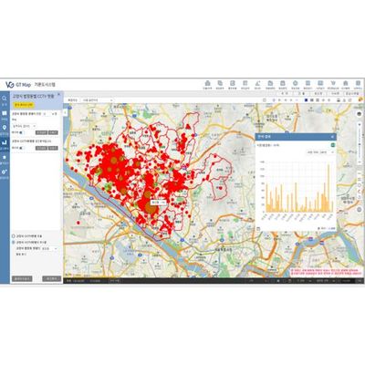
Big data-based spatial analysis
It provides a powerful analysis function based on spatial information targeting the data owned by the institution or all facilities in the system. Analyze all data using topological relationships, then derive results and visualize them on a map.
Analyze various data to derive new information!
Administrator system responsible for system security and management based at once.
The administrator system is a powerful system that can manage user and system usage information through system linkage information, user authority/repository management, and log information
Meet the system with thorough security and management!