
Raymetrics S.A.
- Home
- Companies
- Raymetrics S.A.
- Applications
- Laser based remote sensing instruments ...

Laser based remote sensing instruments for 3D cloud base applications - Monitoring and Testing - Meteorological Monitoring
FromRaymetrics S.A.
Cloud base height is currently measured using ceilometers, which are in reality low spec LIDAR systems. LIDAR is therefore already the standard method of determining cloud base height.
Most popular related searches
laser remote sensing system
3D scanning LIDAR
laser remote sensing
remote sensing system
3D scanning
3D LIDAR scanning
LiDAR system
remote sensing
meteorology monitoring
LiDAR
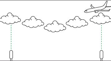
Cloud base height is currently measured with ceilometers (low-spec LIDARs). Each runway often has more than one ceilometer.
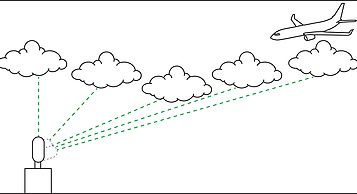
A single 3D scanning LIDAR can measure total ceiling – cloud base in multiple locations - and offer forecasters information about near-future cloud base.
- Incoming cloud base for near-future forecasting
- Total cloud cover
- 3D cloud base (in case cloud is not directly above ceilometer)
- Excellent range (up to 15km with good SNR)
- Particle distinction (dust, volcanic ash, ice/water clouds, smoke, etc)
- Remote visibility / fog detection
Raymetrics` software now performs auto-picking of cloud base (and other atmospheric layers, such as the PBL or aerosol layers). Automatic particle distinction is also available (may require system upgrade).
Stay in the loop!
Select your areas of interest to receive industry updates.