
Point Clouds Explained: The Key to Accurate Digital Modeling
Ever wonder how surveyors, architects, and engineers capture intricate details of buildings or landscapes? They employ point clouds! It’s like making a 3D puzzle out of many little dots, where each dot has a part of the picture to tell. Pretty cool, huh?
These clusters of points are more than data; they're the very foundation of modern construction, surveying, and even robotics.
This tech accelerates projects and reduces costs. It also takes our accuracy to levels we only dreamed of before.
What is a Point Cloud?
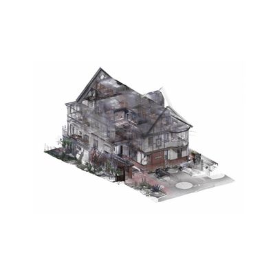
Point clouds are essentially digital snapshots of the world around us. They pluck out spatial information using tech like LiDAR, which can transform real-world scenes into rich data sets. Think of standing in a room and capturing every nook and cranny in 3D with your eyes in a quick second. That's what point clouds do. Each point is not just a random dot, but a precise location in space.
Together, these points form surfaces and objects that we perceive in three dimensions. This is handy because the accuracy is high—every little detail gets recorded.
Remember, they can be generated from many sources—LiDAR, photogrammetry, etc. Every point in a point cloud has these unique Cartesian coordinates (X, Y, Z).
Significance in Various Fields
- In architecture, point clouds are game-changers. They provide accurate as-built models, giving architects a clear view of existing buildings. This helps design better suited to the current context.
- Engineers love them too. They leverage point clouds and conduct structural analysis to make sure everything stands solid and the quality is superb.
- In construction, these digital data sets are the progress diary. They keep an eye on how things are going, ensure everything stays on plan, and create a written record of the entire process. It’s like having a map that tells you exactly where things are at any point in time.
Methods to Generate Point Clouds
When it comes to creating point clouds, two methods stand out above the rest — laser scanning and photogrammetry. These methods allow you to capture the world around us in 3D, resulting in an accurate and comprehensive view. Let’s dig into these a little bit more.
LiDAR Scanning Techniques
LiDAR, or Light Detection and Ranging, uses laser pulses to measure distances accurately. This method sends out a quick shower of laser beams. As they bounce back, they reveal the shape and distance of objects. Modern LiDAR scanners are blazing fast; they can capture millions of points in just seconds. That speed is essential for projects requiring intricate datasets, such as mapping large buildings or complex terrains. LiDAR provides a huge advantage with denser, more accurate point clouds.
Photogrammetry Methods
Photogrammetry uses photos to build 3D models. This technique takes several overlapping images from different angles, extracting spatial information. You can imagine taking pictures of a statue from every direction; photogrammetry will stitch those images together in a 3D model.
This method is especially effective when used in conjunction with other data collection methods. It’s a very affordable and flexible approach. It's ideal for some scenarios where laser scanning can be too cost-prohibitive or excessive, such as with smaller residential work.
Data Integration Processes
Merging different data sources into a single point cloud dataset is key for holistic analysis. Software tools are essential to making this data align and work. They ensure all the points they capture interconnect.
This process, called point cloud registration, involves aligning overlapping point clouds from different scanner positions. It’s a little like putting together a puzzle in that everything has to fit together just so. Combining data from various technologies can be tricky and often relies on specific software and expertise.
Point clouds rock the architectural construction world. They provide precision and detail like never before. Think of turning a huge building project into a digital work of art that captures all the ins and outs. That’s the power of point clouds right there. From planning to execution, these digital data sets lay the groundwork for smarter, faster, and less expensive projects.