

- Home
- Companies
- Aevex Aerospace
- Products
Aevex Aerospace products
Lidar Mapping
Aevex - Model Geo-ECTO-1 - High-End Survey-Grade Mobile Lidar Mapping
The Geo-ECTO-1 mobile mapper is the industry-leading turnkey mobile mapping solution developed by AEVEX. Tailored to each client’s requirements and available in single and dual-LiDAR configurations, Geo-ECTO-1 is an invaluable technology for organizations tasked with assessment of critical transport infrastructure, including bridge and tunnel inspections, road/highway surveying and powerline mapping.
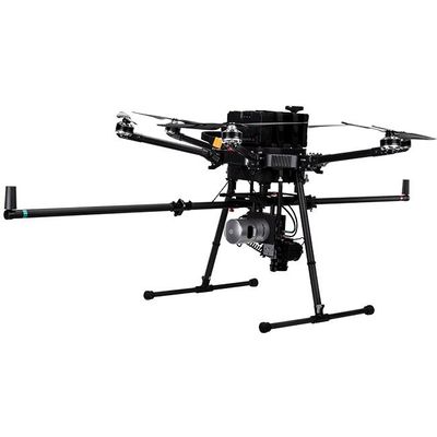
Aevex - Model GEO-MMS - Mobile Mapping System for Lidar & Photogrammetry System
AEVEX’s Geo-MMS (Mobile Mapping System) is a cost-efficient, modular system for drone-based LiDAR and imagery capture solutions. Our three product categories and bundle options cater to a diversity of unique applications, use-cases and mission challenges. AEVEX’s extensive suite of ‘one-click’ advanced processing software provide a powerful, user-friendly toolbox for mobile and UAV-based mapping operations. At the heart of Geo-MMS is AEVEX’s dual-antenna Inertial Navigation System (INS), with tight coupling of LiDAR, RGB, multispectral and other sensors. This Defense-grade proprietary navigation technology has been refined over AEVEX’s 20+ year history to a lightweight, platform agnostic system that can be deployed in minutes.
Assured-PNT for Land, Air and Sea
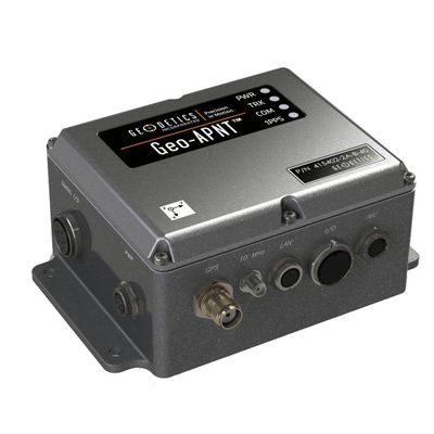
Aevex - Model GEO-APNT - Assured Positioning, Navigation and Timing
The Geo-APNT® is an innovative and ef?cient solution for applications that need precise navigation data, as well as accurate time reference. The Geo-APNT combines a high performance, versatile, GPS master clock with an accurate inertial navigation system that delivers assured position, navigation and timing (PNT) under all circumstances, including temporary loss of GPS, typical of dynamic platforms. The Geo-APNT minimizes size, weight and power (SWaP) due to the integration of positioning and timing that are typically achieved by two independent subsystems.
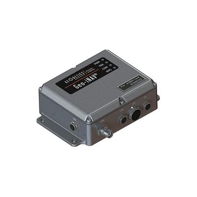
Aevex - Model GEO-INAV - High-Performance, Rugged GPS-Aided Inertial Navigation System
The Geo-iNAV® is a high-performance, rugged GPS-aided inertial navigation system. The Geo-iNAV tightly couples an RTK-enabled dual-frequency GPS sensor with a wide range of IMU’s including fiber-optic gyro and ring- laser gyro IMU’s for the highest levels of accuracy. The Geo-iNAV provides on-board data recording and hosting of user applications via the SDK. Geo-iNAV is designed to meet a wide range of Air, Land and Sea requirements.
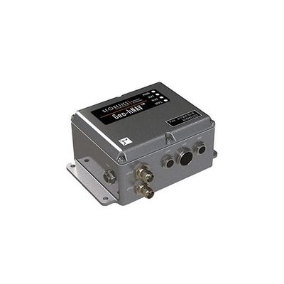
Aevex - Model Geo-hNAV - Rugged, Hybrid Dual-GPS-Aided Inertial Navigation System
Geo-hNAV™ is a rugged, hybrid dual-GPS-aided inertial navigation system which delivers consistent position and attitude measurement accuracy whether the platform is static or moving. The Geo-hNAV combines the best features of the Geo-iNAV inertial navigation system with the Geo-Pointer dual-antenna heading system. For stationary or slowly moving platforms, precise heading is derived from GPS measurements using two GPS antennas rigidly mounted on the platform, separated by a typical distance of 1 to 3 meters. In dynamic conditions, the combination of GPS and IMU provides enhanced position, velocity and attitude measurements.
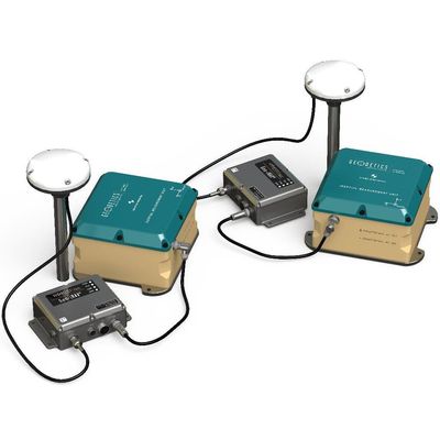
Aevex - Model Geo-RelNAV - High-Accuracy, Real-Time Relative Navigation System
Geo-RelNAV® is a unique navigation system that provides relative navigation information between moving platforms. Information computed by the system includes values such as relative velocity (closure rate) and relative orientation. This information can be used for applications including autonomous driving vehicles, sense and avoid for commercial UAV’s, autonomous platooning (V2V - vehicle to vehicle) and sports action following.
Aevex - Model HGGR - Civilan GPS ACMI Form, Fit, Function Replacement for GNP-10
The HGGR is a cost effective Form, Fit and Function* drop-in replacement for the GNP-10 offering a high-performance GPS/INS based guidance, navigation and control. The HGGR Commercial provides the capability with a Civilian GPS sensor.
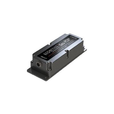
Aevex - Model GEO-PCU - Power Conditioning Unit
The Geo-PCU is a power conditioning unit designed to comply with MIL-STD-704F, MIL-STD-1275D and the following MIL-STD-461F requirements. (Design also includes compliance with related RTCA (FAA) DO-160G, Category B requirements.).