
- Home
- Companies
- BW Geohydromatics
- Software
BW Geohydromatics software
Spatial Desicion Assistance of Watershed Sedimentation (SDAS)
SDAS stands for Spatial Decision Assistance of Watershed Sedimentation. It is a set of functions that produce (instantly) tool to predict annual erosion rate and sediment yield of a watershed. SDAS embedded with some TauDEM executables which is developed at Utah State University (USU) (may be obtained from http://hydrology.usu.edu/taudem/taudem5.0/). This makes SDAS capable to complete hydrological spatial analysis such as hydrologic digital elevation model analysis , river network and watershed delineation from raw Digital Elevation Model (DEM). In other words SDAS is designed to be a “one-button” Geographic Information System (GIS) modeling toolbox.
Model AQUACOD - Assessment of Quality and Analysis of Current Observation Data
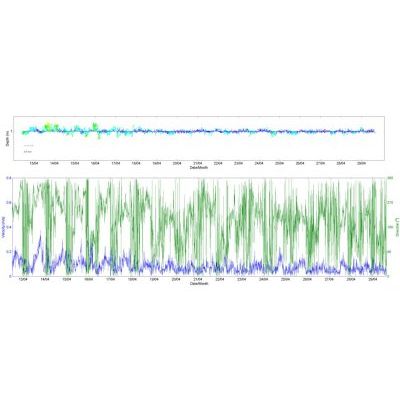
AQUACOD stands for Assessment of Quality and Analysis of Current Observation Data. This software produces (instantly) a set of graphical representation of current observation data. In other words AQUACOD is designed to be a “one button” data processing toolbox.
Model EVA - Extreme Value Analysis Software
The software is to assess, from a given ordered sample of a given random variable, the probability of events that are more extreme than any previously observed. EVA might be used to estimate the value an unusually large flooding event (for example), such as the 100-year flood. Similarly, for the design of a breakwater, a coastal engineer would seek to estimate the 50-year wave and design the structure accordingly.