

- Home
- Companies
- CEE HydroSystems
- Software
CEE HydroSystems software
Hydrogrpaphic Survey Software
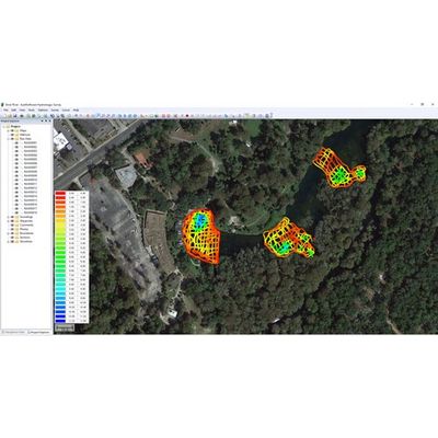
Hydromagic - Model Eye4 - Single Beam Survey Data Acquisition and Editing Software
Hydromagic is a professional hydrographic survey software package for the acquisition and editing of single beam echo sounder surveys. The software is affordable and has been designed to be intuitive, allowing new users with relatively little experience in hydrographic surveying to quickly become proficient and start conducting bathymetry projects. Most menus and settings are accessible from a simple right-click, and the entire package operates from a single menu view making navigation around the user interface easy. The geodetic framework of Hydromagic is rigorous, with over 5000 pre defined local and global map datums and grids available. Surveying with an RTK GNSS receiver providing tide (elevation) data in real time is possible using appropriate geoid models.
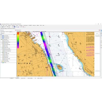
CEE - Model HYPACK - Hydrographic Survey Acquisition and Processing Software
HYPACK software was developed by Coastal Oceanographics, subsequently renamed HYPACK; now a Xylem brand, HYPACK is the most widely used hydrographic survey software package worldwide. With over 10,000 users undertaking shallow water single beam surveys, side scan search and recovery missions, sub bottom sediment profiling, advanced multibeam navigation surveys, or dredging surveys HYPACK software has the capabilities to manage the complete process from the survey to the finished product. Starting at data collection, close cooperation with equipment manufacturers generates specific equipment drivers that are available for the major types of equipment in use; a rigorous geodetic framework guarantees a precise representation of survey results in any coordinate system.