

Chesapeake Technology Inc. software
SonarWiz - Model SIDESCAN - Fundamentals Module
View And Analyze Sidescan Data In Real Time. Wide Variety Of Import And Export Formats. View & Export 2d & 3d Pdf, Web, Google Earth.
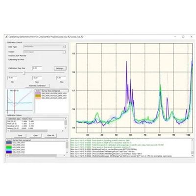
Collecting and Processing MBES and SBES Bathymetry Data Software
Collecting and processing MBES and SBES bathymetry data is a breeze with the SonarWiz workflow and tool set. From the helm display, with a Plan View, Coverage Map and directional indicators, to the automatic, whole survey gain optimization.
SonarWiz - Model SUB-BOTTOM - Fundamentals Module
Explore sediment layers in-depth with SonarWiz for Sub-Bottom Profilers with real-time data acquisition and post-processing modules. It also includes navigation, fathometer and magnetometer inputs so you get a broad perspective of a survey area.
Model SINGLE BEAM - Streamline Survey Software
Easy to use interface for data logging and processing. Data input from single beam sensor, motion sensor and navigation device through serial and network connections. Many tools to process in XYZ to generate and export sounding, grid surface and contours for final products.