

Detektia products
Structural Health Monitoring (SHM)
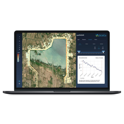
Remote SHM for Dams
Deformation monitoring of dams is key to avoid catastrophic loss of infrastructure and lives. Measuring and monitoring the deformations of these assets is a mandatory task due to the high risk they represent. These monitoring activities are usually based on geotechnical instruments (e.g., direct and inverted pendulum, inclinometers, tiltmeters, jointmeters) and geodetic-surveying methods (e.g., leveling, trilateration, triangulation, angular collimation, GNSS…). Although these methods are very accurate and reliable, they are often time-consuming and expensive, providing very punctual and isolated information.
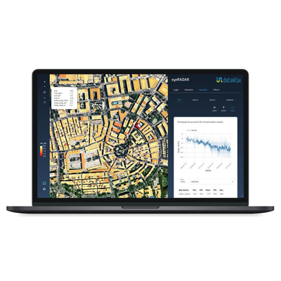
Remote SHM for Tunnels
Monitoring underground infrastructures is extremely important during and after the construction stage. Conventional monitoring techniques are very accurate (topography, levelling, etc.), but quite expensive and limited to isolated points in very small areas. New satellite-based cost-efficient complementary techniques applied to wide areas and capable of analyzing time series are being developed and redefining the control and monitoring of these large urban works.
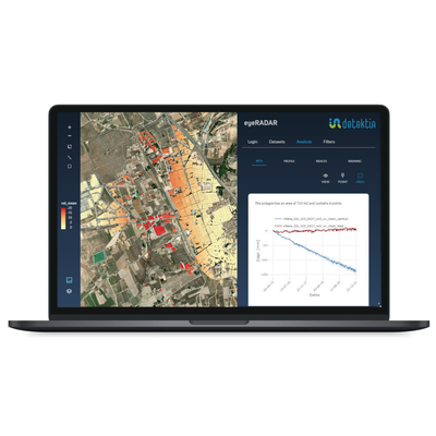
Structural Health Monitoring of Embankments
Detektia develops early warning systems based on the analysis of deformation time series using non-intrusive Radar satellite technologies. This information is combined with other parameters such as rainfall, geology, DEM, geometry of embankments…allowing the generation of dynamic landslide risk models.
InSAR Ground Movement Monitoring
Groundwater Dynamics
Aquifer overexploitation causes water shortages, reduces water quality and causes ground movements, affecting surface topography and infrastructure. The overexploitation of groundwater can generate continuous land subsidence that in some cases affects large areas and even collapses urban structures. Mexico City is sinking 25 cm/year, similar to the rates in Jakarta and Manila, where sea level is also rising due to climate change. Closer to us, in Murcia Region, we find the highest rate of land subsidence in Europe (10 cm/year) caused by aquifer overexploitation. Groundwater is a scarce and dispersed resource, and therefore, control and management is a major challenge. In Spain alone, there are more than 500,000 illegal wells, extracting the equivalent of the annual consumption of 58 million people. Globally, 20% of the world’s aquifers are overexploited and the number continues growing. New tools are needed to effectively control the overexploitation of aquifers over large areas at a competitive cost.
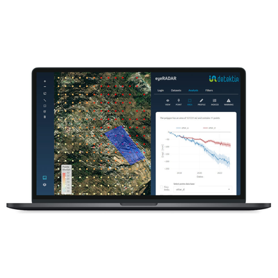
Landslide Prevention and Control System
A landslide is a large-scale movement of a mass of earth, rocks, debris, or geological material moving downhill. It is characterised by the displacement of large amounts of soil, caused by gravity and other factors such as erosion, soil saturation due to heavy rains, or terrain destabilisation by earthquakes or other geological activities. Landslides can vary in scale from slow and gradual movements to sudden and catastrophic events, and can cause significant damage to structures, transportation routes, and even pose a risk to human lives. While it is possible to predict slopes that are prone to landslides, foreseeing the exact moment of a landslide is not always easy due to the numerous factors involved in the formation of these events. The integration of DInSAR technology with other sources of information (precipitation, geology, topography, etc.) can play a crucial role in preventing disasters related to landslides, especially in large areas where traditional control techniques are not technically or economically feasible.