
- Home
- Companies
- GEOREKA Software
- Software
GEOREKA Software software
GEOREKA - Geological Modelling Envision Software
Our viewer imports a large variety of data. It can be used to dynamically visualize cross-sections and export them as (high-resolution) images. This version is free to use for research or commercial work. We only request you register your details through our 30 day trial download page. You will then receive an email with a link to the full trial version. At the end of the trial, the software automatically falls back to a Viewer. It has all the essential visualization options such as importing supported data types, adjusting size and transparency and includes the option to save settings and add comments. GEOREKA’s free Geology Viewer is the ideal tool to share your data with clients and other stakeholders. Click the link below to go to the download page.
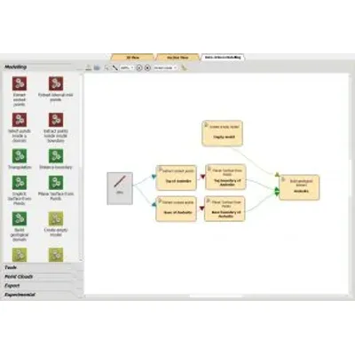
GEOREKA - 3D Geological Modelling Software
GEOREKA’s 3D geological modelling software is versatile and adaptable. It is a like a Swiss army knife with many different tools. In combination with its unique modelling approach it can be made to fit any project be it Mineral Exploration or Industrial Minerals. The heart of all modelling is a data-driven processing engine. This engine provides implicit, data-driven modelling tools for both geological and numerical features. Here we will provide quick overview of most fundamental tools.
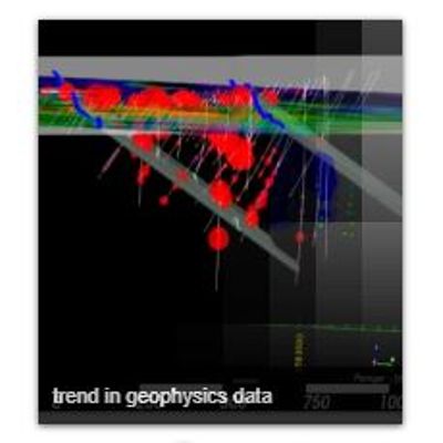
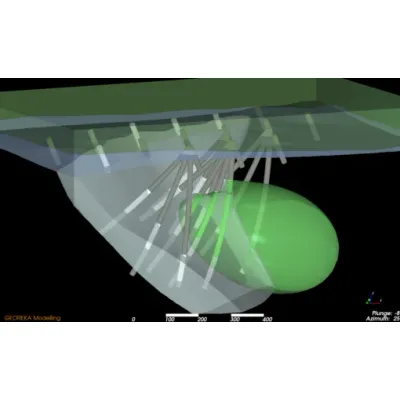
GEOREKA - 3D Mineral Exploration Software
Here, we highlight some tools in our software specific for mineral exploration that can help you quickly understand the 3D geology and trends in your exploration data.
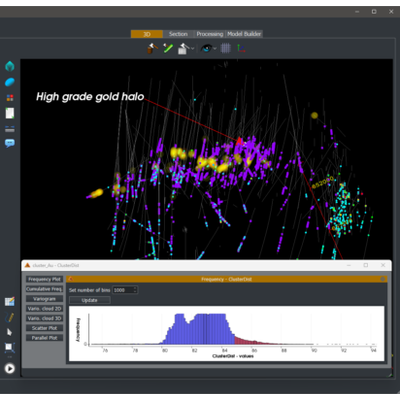
GEOREKA - Multi-element Geological Data Clustering Software
This article discusses a novel technique for multi-element geological data clustering developed by GEOREKA. The approach is designed to improve the understanding of geological domains and formations by utilizing a form of clustering termed 'domaining.' Traditional methods like Kriging, which relies on single-element interpolation, have limitations, particularly in multi-element data analysis. The innovative technique employs a machine learning-inspired method known as multi-dimensional similarity clustering. Instead of focusing solely on spatial coordinates (X, Y, Z), this technique takes into account multiple chemical elements such as As, Au, Cu, Mo, and Zn, thereby creating a higher-dimensional space or hyperspace for analysis. By determining similarity patterns across these dimensions, the method allows for the identification of clusters based on comprehensive similarities. Practical applications have demonstrated its effectiveness in predicting lithological units and identifying high and low similarity regions, although the sensitivity to selected reference points requires further investigation.
GEOREKA - Machine Learning Software for Geological Modelling
The growing interest in machine learning (ML) has extended into geological modelling, enabling efficient 3D reconstructions of geological features from limited data. By focusing on categorical data rather than numeric ones, ML can swiftly classify geological units based on predefined categories like lithology, which is essential for constructing realistic geological models. The process involves using ML classifiers to define volumetric domains, where data points are labeled to distinguish between different geological units. This method bears similarities to implicit modelling approaches used in the industry for over two decades. A notable example includes using a simple artificial data set, Marvin, to illustrate domain creation using ML classifiers instead of traditional interpolation techniques. By integrating ML into existing geological workflows, users can easily compare results with traditional methods like Ordinary Kriging or implicit modelling, enhancing intuitive adoption of machine learning while maintaining familiar processes.
GEOREKA - Signed Distance Functions: Beyond Implicit Modelling Software
For about two decades now, the industry has been using the term implicit modelling intertwined with the term Radial basis functions (RBFs). It has become the de facto standard and has given people an appreciation of the method compared to explicitly digitizing domains. In the mining industry the terms implicit modelling and RBFs are used almost interchangeably. However, that is somewhat erroneous. The term RBF is common term in mathematics. They represent a class of functions that radially spread outwards from a point. An implicit representation of a function on the other hand defines objects like spheres and planes as a single function. What has been called implicit modelling in geology is actually a system fitting RBF functions to the data, not unlike regression, which we will come back to. The interesting part about fitting RBFs is that in that capacity they actually belong to a much larger group of functions called Signed Distance Functions (SDFs).

GEOREKA - Intuitive Machine Learning Software for Geological Modelling
Intuitive Machine Learning focuses on leveraging machine learning techniques to enhance geological modelling, particularly through the application of classification methods to categorical data. Unlike traditional numeric input methods like assay analysis, this approach enables a more efficient and faster categorization of geological spaces in 3D modelling. By labeling areas with categories such as lithology, a classification system is created that allows for efficient modeling. This method draws parallels to implicit modelling, which has been used in the geological industry for over two decades, but it uses machine learning classifiers to distinguish geological domains effectively. The approach simulates real-world 3D geological reconstructions from limited available data, using classification functions to determine whether a point belongs to a specific geological unit. The integration of machine learning with existing domain-specific anisotropy methodologies ensures a seamless transition for practitioners while offering a significant step forward in geological data modelling.
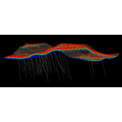
GEOREKA - Geological Modelling Software for Stratigraphic Drillhole Data
GEOREKA Software provides a comprehensive toolset for stratigraphic modelling, aiming to simplify the process of constructing geological models from stratigraphic drillhole data. The software supports various topography data inputs, including LIDAR scans or triangulated surfaces, facilitating the creation of accurate topographic models. When external data is unavailable, collar points can be utilized to estimate the local curvature and form indicator points. GEOREKA further assists in transitioning lithology data into implicit representations to model the overburden layers efficiently. It implements a functional modelling approach, where stratigraphic layers are sequentially converted into indicator points, minimizing overlaps by considering the relative age of geological units. This process ensures younger units are modelled before older ones, maintaining the integrity of the stratigraphic sequence. The final stratigraphic model is constrained by the domain functions and the chronological order of units, resulting in a precise and orderly representation of the geological structure.
GEOREKA - Machine Learning (ML) Demystified Software
Machine Learning (ML) techniques, often perceived as complex, have been increasingly discussed across various industries, including mining. Despite some skepticism regarding their effectiveness, ML offers valuable solutions when correctly understood and applied. Key ML methodologies used in geological modelling include Neural Networks (NNs), Support Vector Machines (SVMs), and Gaussian Processes (GPs). Each of these has unique features; for instance, GPs are akin to Kriging, allowing for variance estimation between known data points. SVMs efficiently separate data categories using hyperplanes. Meanwhile, NNs, while computationally intensive to train, are excellent for function approximation once trained. However, a major challenge is integrating ML with geological knowledge, given ML techniques don't inherently understand geological parameters like anisotropy. Thus, success relies on adept data preparation and geological understanding. By incorporating variography with ML, geologists could optimize their modelling efforts, thereby demonstrating the continued relevance of traditional geological techniques in conjunction with contemporary ML tools.