

Geosoft International software
Rock Mechanics
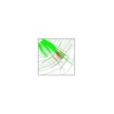
Geosoft - Model ROTOMAP - Rockfall Protective Systems
ROTOMAP is a three-dimensional model that is used for rockfall analysis and the design of rockfall protective systems. This module belongs to the Isomap family: please check the ISOMAP page for a complete description of the main module features. ROTOMAP uses a statistical approach; it simulates a large number of rockfalls and, through the analysis of the distribution of the average and maximum kinetic energies, identifies the optimal areas for the installation of the protective systems. The program requires a detailed topographic map and a geomorphologic data collection to identify the areas where a rockfall can initiate, and to distinguish the different surface types, such as clean faces of hard unweathered rock or surfaces covered in talus, scree or gravel material.
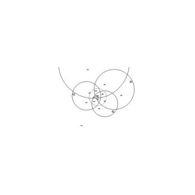
Geosoft - Model ROCK3D - Three-Dimensional Rock Block Analysis Based Key Block Theory
ROCK3D is a program for stability analysis of removable blocks on planar rock slopes. It identifies and analyses all the blocks that have formed under each kinematic mode. Once the geometry of the rock blocks has been identified, the bolt forces necessary to reach a required safety factor are calculated. The structural geology data collection is carried out through the introduction of the joint orientations and the co-ordinates of the end points of the joint traces that are visible on the slope surface. The rock slope orientation and the rock mass parameters are also necessary for the evaluation of the safety factors and for the design of the rock bolts.
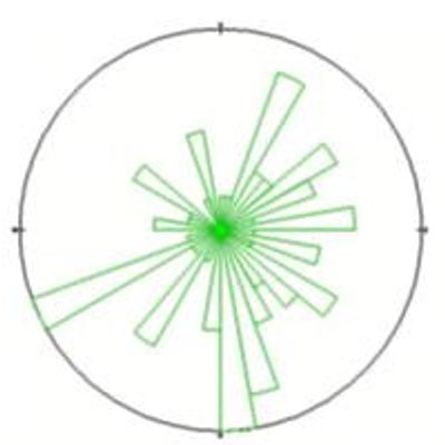
Geosoft - Model CLU_STAR - Program for Computerised Structural Geology Data Collection & Analysis Software
CLU-STAR is a program for computerised structural geology data collection and analysis. The program recognises the discontinuity sets of a rock mass through hierarchical and non-hierarchical clustering procedures derived from the multivariate analysis. These clustering procedures operate directly on the collected data instead of on their statistical distribution; the results are consequently closer to the geomechanical reality. The high interactivity of the program offers the operator a better control of the full sequence of operations, as it is possible to choose the clustering level (and hence the dimension of the clusters), as well as the algorithms for the assignment of the joints to the individual discontinuity sets.

Geosoft - Model Accecalc - Rock Slope Stability Analysis Under Seismic Conditions Software
The program analyses the behaviour of the rock slopes under seismic conditions. It evaluates the displacements of a rock block subject to dynamic forces, on the basis of a given accelerogram. The use of a calculation method based on a given accelerogram for rock slope stability analysis allows one to take into account the duration and the intensity of the accelerogram itself (this not being the case with the normally used limit equilibrium methods). This allows a more realistic estimation of the effects of a seismic event on a potentially unstable rock block.
Geosoft - Model Clasrock - Classification of Rock Masses Software
The program classifies rock masses using both the Bieniawski and the Barton methods, making it thus possible to compare the results that can be obtained with the two most frequently used classification methods. The Bieniawski classification (RMR Index) evaluates different parameters to which a numerical coefficient is assigned. The sum of these coefficients determine the Rock Mass Rating class the rock mass belongs to.
At the end of the analysis, the program calculates the GSI index (Geological Strength Index) using the relation GSI = RMR89 - 5, Where RMR89 is evaluated by placing the rating of the parameter over a presence of water equal to 15, and the correction parameter over the direction of the joints equal to zero.