

Hydronia LLC products
Model RiverFlow2D - Two-Dimensional Hydraulic and Hydrological Modeling
RiverFlow2D is the most advanced two-dimensional combined hydraulic and hydrologic flexible-mesh model, offering a high-performance finite-volume engine for speedy, accurate, and volume conservative computations in all river and estuary projects. It can tackle the most demanding flood modeling situations including dam-break and levee-break simulations over initially dry terrain. RiverFlow2D can be readily extended with Add-on Modules: Sediment Transport (ST), Mud and Tailings Flow (MT), Pollutant Transport (PL), Water Quality (WQ), Urban Drainage (UD) and Plastic Transportation (PT). RiverFlow2D can use two Graphical User Interfaces (GUI): QGIS or Aquaveo SMS(*). Both GUIs allow generating the files needed to run the model.
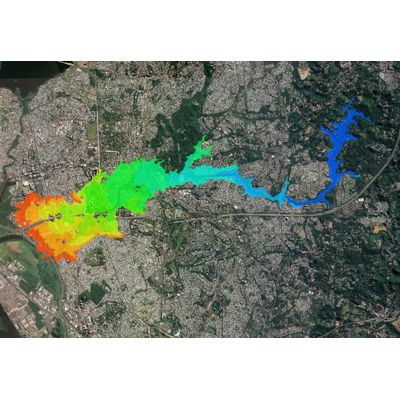
Mud and Tailings Flow (MT) Module
Mud and Tailings Flow (MT) module is a comprehensive computer model capable of simulating inundation from sudden failure of tailings dams, and a wide range of hyperconcentrated flows ranging from non-Newtonian mud and debris flows to the movement of dry granular materials. According to the Canadian Dam Association review of models to simulate tailings runout flows (*), RiverFlow2D is the only two-dimensional model capable of addressing the four typical tailings dam break scenarios (Cases 1A, 1B, 2A, and 2B). RiverFlow2D MT model is the more complete and fastest software to make the most realistic flood risk assessments originating from sudden Dam and Tailings Dam Breaks. Selecting one out of 8 non-Newtonian rheological laws, the model can consider changing tailings properties that cover virtually all possible tailings ranging from relatively low-density high-water content fluids to granular materials.
Sediment Transport Module
The Sediment Transport (ST) module for QGIS and SMS(*) GUIs is an add-on software that complements RiverFlow2D hydrodynamic computations with capabilities to simulate erosion and deposition in rivers and estuaries. The ST module includes formulations that consider transport of fine sediment in suspension, coarser sediment using bed load approach, and combined suspended and bed load transport. It provides options to use multiple sediment size fractions. The RiverFlow2D ST model is the right combination to assess impact of designs to control erosion in rivers, river reach geomorphologic analyses for restoration assessments and evaluating the evolution of the river bed changes for diverse scenarios.
Pollutant Transport Module
The Pollutant Transport (PL) module for QGIS GUI allows simulating the movement of contaminants in water. It is fully coupled with the RiverFlow2D hydrodynamics calculations and considers solute transport by advection, dispersion and reaction. The PL module relies on the depth and velocities calculated by RiverFlow2D and computes solute concentrations at each time step for all cells. The module can consider multiple reactive contaminants that can exchange mass with one another based on first order reaction terms. Now PL module GPU with high-performance capabilities.
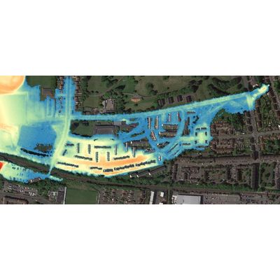
Urban Drainage Module
The Urban Drainage (UD) model for QGIS GUI integrates the capabilities of the EPA-SWMM* Storm Drain model with RiverFlow2D model. This allows performing simulations of urban flooding with full and dynamic interaction of the surface runoff with the storm drain network routing. Presently, the UD module does not integrate surface water quality with the SWMM water quality option. You can integrate existing pipe network SWMM 5.1 projects with RiverFlow2D meshes developed to simulate rainfall, infiltration, flow along streets, considering weirs, gates, and other urban structures. The flow exchange can be in both directions including manhole overflows that bring inflow onto the surface water mesh, and inflow from the surface into the storm drain network.