
Inertial Labs, a VIAVI Solutions Company articles
Abstract
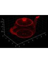
Beginners using LiDAR for the first time often struggle to understand a point cloud and how to work with it. Therefore, this paper discusses a point cloud and how it is generated using LiDAR.
Here are the sections that will be covered: Introduction to Point Cloud, Step-by-step process for creating a Point Cloud, Additional data contained in the Point Cloud, Point Cloud data processing, Using Point Clouds. The conclusion will summarize the benefits of usin
Global Navigation Satellite System (GNSS) and Satellite Navigation Explained
Abstract
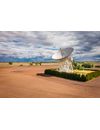
Global Navigation Satellite System (GNSS) technology is a collection of satellite positioning systems with worldwide coverage. These systems aid in positioning, navigation, and timing (PNT) applications for commercial and military purposes. Due to its critical role in everyday life, it is vital to understand the system architecture. This pape

Abstract.
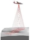
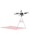
Light detection and ranging (LiDAR) technology has recently been used to solve many problems in various fields. Quarry mining is no exception. LiDAR scans the quarry and determines essential parameters such as the depth and volume of material mined during the planning stage and throughout the quarry’s life cycle.
This paper examines the use of LiDAR in the mining industry and how LiDAR can help save money by providing the necessary data for job pla
Abstract.
Thanks to technologies such as light detection and ranging (LiDAR), power line inspection has recently become automated. LiDAR is used to assess the condition of wires and supports, create terrain maps for upgrading existing lines or laying new ones, and assess the risks of vegetation's influence on the integrity of structures, which is vital for industrial activities and human life.
The sections covered will be Introduction to LiDAR, Powerline Inspe
Abstract.
Monitoring the health of estuaries is very important to maintain the ecological balance of flora and fauna. Their survey has become fast and efficient thanks to technologies like light detection and ranging (LiDAR). LiDAR is used to construct digital terrain maps (digital surface models, digital terrain models), assess the state of coastal vegetation, and assess the ecological state of estuaries.
The sections will
Abstract.
Light detection and ranging (LiDAR) technology is finding new applications in various industries. Due to its high data accuracy, speed, and safety, LiDAR has found its application in construction. People often wonder why construction takes so long to complete. Using LiDAR in construction practices can improve design accuracy and efficiency, improve safety, and optimize construction project management. LiDAR provides detailed and accurate 3D models, all
Common issues and solutions for systems that combine GPS and INS technologies.
Inertial Labs offers various GPS-integrated systems, such as the INS, MRU-P(D), and WS-PD. This article aims to provide details on troubleshooting for users` most common errors with these devices. We encourage users to read their device’s latest Interface Control Document (ICD) and Graphical User Interface (GUI) manual for further information. These documents are available on th
Abstract:
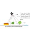
LiDAR, which stands for Light Detection and Ranging, is a remote sensing method used to examine the surface of the Earth. It employs laser light to measure distances to the Earth’s surface, generating precise, three-dimensional information about the shape of the Earth and its surface characteristics. LiDAR technology has many applications, including topographic mapping, forestry, agriculture, urban planning, and autonomous vehicles. This article discusses using LiDAR to
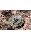
Abstract.
Over the past couple of decades, Light Detection and Ranging (LiDAR) technology has become common in many areas. Military applications are no exception, where LiDAR is used to detect explosive objects and mines on the earth's surface. This article discusses the use of LiDAR in searching for mines and unexploded ordnance and how it complements modern technology.
The sections covered will be Introduction to LiDAR, Current Demining, and its Technology, and How LiDAR can h
Abstract:
Over the years, Light Detection and Ranging (LiDAR) has gained traction and popularity in many different work scenarios, including farming. This paper presents a dive into the precision agriculture industry with LiDAR to show its usefulness in improving farm production and efficiency, specifically when applying fertilizer. Fertilizer costs change throughout the year, so methods must be used t