

Infinite Jib Inc applications
The purpose of surveying has remained somewhat the same over time: establishing boundaries, creating maps for navigation, and developing land. However, while the purposes remain constant, the survey tools used over time have progressed alongside human technology, and with each advancement, they improve the accuracy and speed at which surveying can be done. In recent years, the Geomatics industry has been captivated by the possibilities of working with unmanned aerial systems (UAS). Survey companies are actively transitioning from testing UAV systems to integrating our technology into their enterprises.
One concept that comes up over and over is around how UAVs shouldnt be thought of as a solution that`s going to solve every problem on a project, but instead as tools that create options and expand alternatives. Engineering companies have been at the forefront piloting UAVs exploring the potential of our technology`s versatility. The ability to reliably capture, accurate data with our aircraft systems, has expanded and created opportunities in the engineering sector.
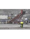
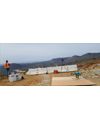
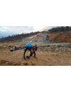
Stockpile volumetrics is a widely used application of UAV technology in the mining sector. Having volumetric surveys completed at regular intervals provides an accurate measurement of the amount of material that has been moved in that time. Historically ground surveyors have conducted stockpile measurements with GPS rovers. Today, this work can be accomplished with your UAS and eliminate the need for crews to work in potentially dangerous situations.

The implementation of our technology is currently undergoing a major uptake in popularity as the commerciaj^vorld continues to determine applications for UAVs to collect valuable data. Data continues to be one ottne most powerful tools at your disposal. The technology of Infinite Jib™ provides you with a reliable/efficient and accurate collection method.