

Leica Geosystems AG - a Hexagon company software
Information Management
Leica Virtual Vista
With simplicity and the best possible user experience in mind, Leica Geosystems developed Leica Virtual Vista™. The web based platform delivers telematics and a flexible data management solution via the built-in modem of the Leica mojo3D. It can be accessed within a few simple steps from any computer –anywhere and anytime. Leica Virtual Vista™ provides a convenient overview about activities in the field by combining real time and historical information with the use of Google Maps™. Registration is available for all Leica mojo3D users at www.VirtualVista.com. After creating an account, users can link their Leica mojo3D devices and start using the service instantly. No additional hardware has to be purchased to use the service.Leica Virtual Wrench
Leica Virtual Wrench™ is the Ag industry`s first web-based remote service, support and diagnostics tool, available exclusively to Leica Geosystems authorized technicians to provide superior support to our customers. We see what you see!
Steering Solutions
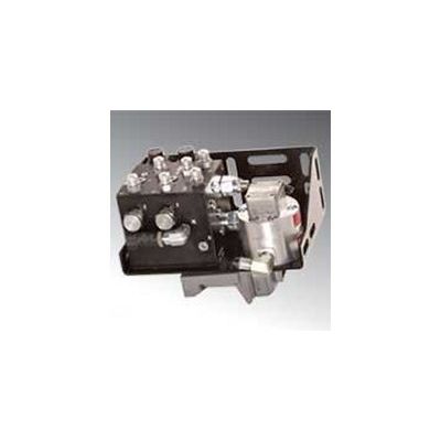
Leica SteerDirect Hydraulics
The Leica SteerDirect Hydraulic system is a compact integrated solution that connects the Leica guidance solution to the vehicle’s steering system via a single-bracket hydraulic kit for high-end steering. This unique hydraulic solution is strategically designed with a number of cost-saving features, including a single bracket and a simplified design that requires fewer components and streamlines the installation process to save time and money.
UAV Systems
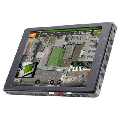
Leica Aibot - Model skyCAPP - Professional Flight Execution App For Highest Safety For Uav Operations
Leica Aibot skyCAPP is designed for optimal control of the Leica Aibot UAV platform during flight execution. Manage the mission and automatically capture data according to pre-set flight plans. Primary and secondary screen views allow pilots to switch between real-time streaming of two on-board cameras and a map view. Seamlessly pause and resume missions, manage battery life safely and easily switch between camera and video mode so you can focus on flying the UAV. Aibot skyCAPP improves the flying experience of the Leica Aibot and supports pilots by automating important flying functions and system configuration.
Leica - Infinity Survey Software
Infinity is the user-friendly geospatial office software suite for the measurement professional. It is designed to manage, process, analyse and quality check all field survey measure data, including total stations, digital levels, GNSS data and Unmanned Aerial Vehicles (UAVs). So whether it’s measuring new survey projects or preparing data for construction layout jobs, Infinity supports your workflow.