

Leraand Engineering Inc. (LEI) software
SonarTRX - Sidescan Sonar Processing Software
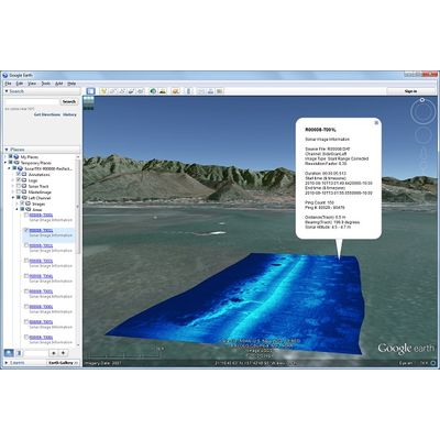
The main focus of SonarTRX software is the generation of geo-referenced raster images from sidescan sonar recordings. SonarTRX can also be used to extract depth (echo soundings) from these recordings, for bathymetric processing with GIS or 3`rd party terrain processing utilities. SonarTRX can be part of a very affordable tool-kit for exploring & mapping the seabed from your kayak, jet ski or small boat.
SonarTRX Pro - Model x64 - Sidescan Sonar Processing Software
SonarTRX Pro (x64) has the ability to import sonar files from several sonar manufacturers and generate geo-referenced images from the sidescan data. It can extract depth-along-track as estimated by the sonar, at various time-intervals (1, 2, 5, ...) from the default sonar channel, for bathymetric processing. It can also calculate the "first echo return" based on the recorded sonar data, and allows for digitizing the seabed manually to define the depth used for slant range correction, should that be necessary. SonarTRX Pro (x64) requires a 64 bit Windows operating system, which compared to a 32 bit system is capable of better utilizing available physical memory. This allows for loading larger sonar recordings and creation of larger MasterImages.
SonarTRX-PlusPack - Model v2A - Sidescan Sonar Processing Software
PlusPack v2A is an add-on product license that activates additional depth-export, track-line correction and export functionality within SonarTRX v20 and newer: Import/Export of alternate data (corrected trackline, absolute elevations, transducer altitude...) Export of a more detailed along-track depth-profile (XYZ data) for bathymetric processing of data from specific channel. The exported depth can be values estimated by the sonar itself, or values as calculated/digitized via SonarTRX. The exported data also includes time-stamps and water temperature, if available in sonar recording. When used with SonarTRX v21 and newer, PlusPack v2A also enables option to Batch-export depth-along-track from multiple recordings. Depths are as estimated by sonar, from default sonar channel, and the export-interval is limited to a point every 2 seconds.
SonarTRX-PlusPack - Model v2B - Sidescan Sonar Processing Software
PlusPack v2B is an add-on product license that activates additional raster image-generation features within SonarTRX. The following additional image-tile types can be generated when PlusPack v2B is used with SonarTRX v23: Raw images for each image-tile. The raw images contains one pixel-row per sounding, similar to a waterfall display without any speed correction. These images are saved to a separate output-folder, along with a CSV file containing image-attributes. Rectangular speed corrected images for each image-tile, similar to a speed corrected waterfall display. The images has an along-track scale equivalent to the scale of the corresponding geo-referenced image-tile. This is the preferred image-tile format for down scan channels. The images are saved to a separate output-folder, along with a CSV file containing image-attributes.