

- Home
- Companies
- Mapbis Inc.
- Software
Mapbis Inc. software
Geographic Information System - GIS
GIS (Geographical Information System), is a decision support system that collect, storage, update, analyze and display spatial and geographical location-based data for a specific aim from Earth’s surface.
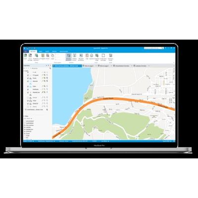
MapInfo Pro - The World`S Premier Desktop Mapping Application
MapInfo Pro helps business analysts, planners, GIS professionals – even non-GIS users – gain new insights into their markets, share information-rich maps and graphs and improve strategic decision-making. MapInfo Professional is a powerful mapping tool, and is packed with features to help you to see trends and patterns, so you can make informed decisions and develop your business.
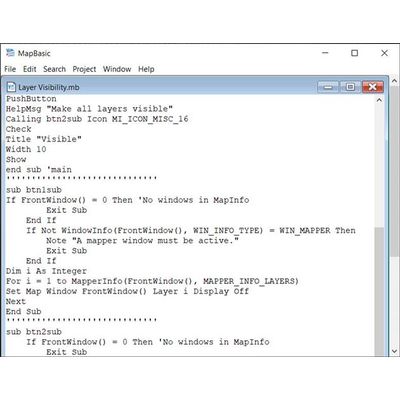
MapBasic Software
MapBasic is a complete, BASIC-like programming language used to create custom applications for use with MapInfo Professional. Use MapBasic to extend geographic functionality, automate repetitive operations, or integrate MapInfo Professional with other applications – quickly and easily. With MapBasic, a custom application can be as simple as adding a menu item to MapInfo Professional or as sophisticated as redesigning the entire user interface and extending the functionality of MapInfo Professional. You can modify the MapInfo Professional user interface by adding customized toolbars, menus and dialog boxes to suit the specific needs and technical sophistication of the end user. You can even hide unneeded functionality or change the terminology to reflect a specific application. Most importantly, MapBasic is easy to learn and use. Most users with very little self training can program in MapBasic in a matter of hours.
iNavi (Indoor Navigation) Software
iNavi (Indoor Navigation) is a 100% local indoor location detection and navigation system that works using only a smart phone, independent of hardware.
HydronetMaestro: Water Infrastructure Management Software
HydronetMaestro is a ready-to-use software environment that simplifies the management of water and wastewater infrastructure. HydronetMaestro is GIS-based, so all data are digitally integrated for easier monitoring: subscriber information, network status, and network inventory. For each subscriber in the customer information system, a location in the real world is known. This knowledge effectively guides procedures such as meter installation/removal and network maintenance, and defines exactly which subscribers are affected. Also, water consumption and projected need can be calculated and reported by location.