
- Home
- Companies
- OceanWise Ltd.
- Software
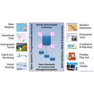
OceanWise Ltd. software

OceanWise - Productivity Tools - Maritime Toolbar and Workflow Extensions Software
Powerful and easy to use tools for manipulating maritime data. Maritime Toolbar and Workflow Extensions are a suite of software tools, developed in conjunction with ports and coastal authorities that manage marine and coastal assets, streamline your workflows providing improved decision support and situational awareness in activities such as:

OceanWise - Dredging and Licensing Management Software
Streamline tasks related to the management and reporting of your dredging operations.
OceanWise - Hydrographic Survey Management Software
Manage and plan your hydrographic survey programme.

OceanWise - Environmental Samples Management Software
Facilitating easy storage, management and sharing of environmental samples data. The Environmental Samples Management Extension helps you simplify the often complex and time-consuming tasks related to the gathering and managing of water quality and other environmental data.

OceanWise - Object Based Image Analysis Software
Interpret and digitalise areas and boundaries in an image quickly and easily. Remote Sensor Object Based Image Analysis or ‘RSOBIA’ is a NEW extension to Maritime Toolbar for Esri ArcMap, which takes raster imagery and segments the data into geographic areas with similar statistical properties. It interprets and digitises the areas and boundaries seen in imagery (such as sidescan sonar and multi-beam backscatter) and creates a polygonised map of the results (e.g. areas of similar seafloor type). It supports Segmentation and Classification which are key techniques for image analysis, and gives quick, easy, repeatable results.
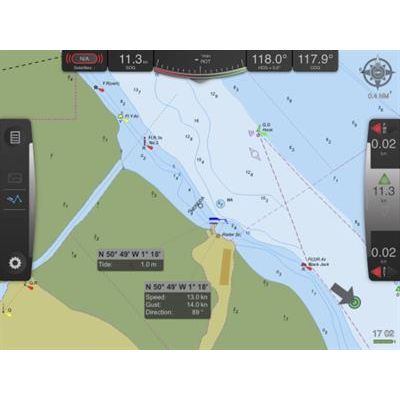
OceanWise - Electronic Navigational Charts (ENC) Production Software
Create Bathymetric and Port ENCs easily within an integrated system. Maritime professionals, such as Port Pilots, VTS Operators and Harbour Masters, are demanding higher resolution and comprehensive datasets to deliver safe and efficient port and maritime operations. The ENC Writer Extension for Maritime Toolbar enables you to produce your own Bathymetric and Port ENCs to:
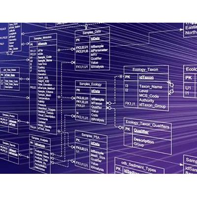
OceanWise - Ocean Database Management Software
Proven and flexible data management solution for all common types of marine data. Ocean Database (ODB) provides you with a complete data management solution that loads and stores many standard type of simple and complex marine and environmental monitoring data.

OceanWise - Enterprise GIS Software
Realise the full benefits of using Geographic Information Systems. We can help you realise the full value and benefits of using Geographic Information Systems (GIS) to store, analyse and disseminate environmental, asset and other data with a spatial component.