

OroraTech GmbH software
OroraTech - Wildfire Management Platform
OroraTech provides a comprehensive wildfire management platform that combines data from over 25 satellites with AI-driven analytics. This system delivers near-real-time monitoring and actionable insights for effective fire management. Users can detect fires early, analyze fire dynamics, and assess the risk of fire propagation. The platform offers tools for post-fire impact assessment, enabling the quantification of burnt areas and the evaluation of vegetation damage. With high-resolution weather and terrain data, the platform aids in risk prediction by using critical factors like temperature, humidity, and wind speed. It integrates seamlessly into existing workflows via API and provides instant alerts through various communication channels. Available in multiple languages, the platform supports decision-makers at every stage of wildfire management, minimizing false positives and helping to safeguard critical infrastructure, natural resources, and biodiversity around the globe.

OroraTech - Model Fire Spread 2.0 - Rapid and Precise Wildfire Predictions Solution
OroraTech specializes in providing rapid and precise wildfire predictions to assist in proactive protection measures. Their Fire Spread solution utilizes advanced fire spread simulations, incorporating real-world data such as wind conditions, elevation, and vegetation to generate accurate predictions in seconds. This system enables users to simulate fire scenarios and predict the direction and speed of fire spread, thus aiding in crucial decision-making processes. OroraTech integrates data from global sources like Copernicus DEM and ESA’s World Cover Map to enhance prediction accuracy. The solution can export results in GeoJSON or KML format for compatibility with GIS platforms, facilitating integration with existing workflows. Designed for various industries, it aids in civil protection, infrastructure safety, forestry management, and carbon tracking. Customization features allow for scenario-specific simulations and parameter adjustments, empowering users to fine-tune predictions based on local conditions. OroraTech supports collaboration through simulation sharing capabilities, enhancing coordinated emergency responses.
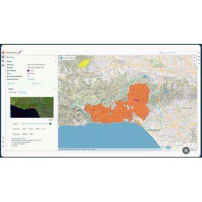
OroraTech - Satellite-Based Wildfire Burnt Area Assessment Software
OroraTech offers an advanced Burnt Area Mapping Solution that leverages high-resolution satellite data to provide precise and swift assessments of wildfire damage across the globe. The system is designed for rapid analysis, delivering critical fire damage data within 2-3 days of a wildfire event. This enhances speed and accuracy, enabling efficient resource allocation and minimizing recovery times and costs compared to traditional ground-based surveys. Operating at a spatial resolution of up to 20 meters, the product ensures high precision, even in remote or challenging locations, and tracks fire progression with detailed timestamps. It’s equipped with an automated and scalable detection system, providing a cost-effective alternative to aerial mapping. This solution aids various sectors such as civil protection, infrastructure, forestry, and carbon management in fast post-fire responses, comprehensive impact assessments, and transparent communication with stakeholders, supporting an integrated approach to managing wildfire recovery and resource planning.