

PIONEER Technologies Corporation software
Geographical Information Systems (GIS) Design and Implementation
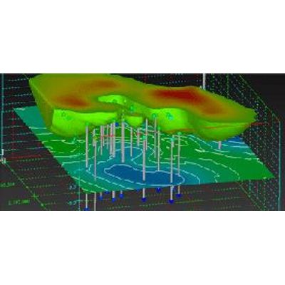
At PIONEER we utilize cutting edge technology including Environmental Visualization Systems (EVS) and Geographical Information Systems (GIS) to create highly advanced maps and cross sections, perform spatial analysis, and depict site contamination. We are experts at creating simple, yet effective, maps that communicate site conditions with customers, agencies, stakeholders, and the community, in addition to solving complex spatial problems. Programs such as EVS allow us to depict plume modeling and create fence diagrams.

Data Management Software
PIONEER has the unique ability to expertly apply computer technology to risk assessment and environmental issues. Our software programs allow us to focus our time and effort on managing big picture issues, rather than managing spreadsheets and worrying about data entry and errors in calculations.