- Home
- Companies
- Roadscanners Oy
- Software
Roadscanners Oy software
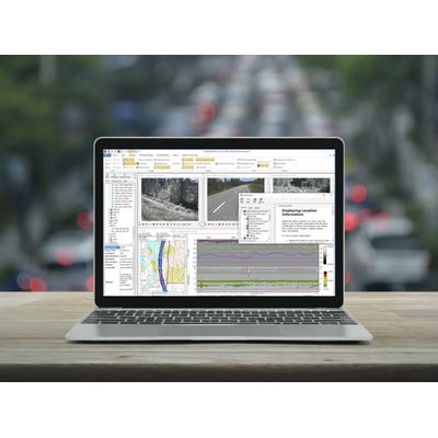
Road Doctor - Surface and Sub-Surface Data Analysis Software, GPR
Road Doctor software is a great tool for engineers, geophysicists or geologists who handle very large surface and subsurface datasets. It brings together in the same synchronized view GPR, Map, Point-cloud, Video, 360 Video, Ground truth, Falling weight, Profilometer, Data-base, and other data. Excellent for example for GPR Data processing and handling. Road Doctor software is not tied into any GPR manufacturer. Results can also be viewed and presented also with Road Doctor Viewer software (it’s free) and Road Data Center online service.Roadscanners Road Doctor - Advanced Software for Infrastructure Data Analysis and Presentation Software
Roadscanners’ Road Doctor® software is advanced software for infrastructure data analysis and presentation. It is specifically designed to empower engineers, geophysicists, and geologists in their data analysis tasks. Road Doctor® is an ideal solution for handling extensive surface and subsurface datasets, making it an invaluable tool for decision-makers seeking valuable results.
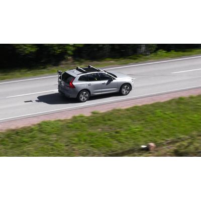
 Roadscanners’ Road Doctor® stands out from other software solutions with its distinctive ability to simultaneously analyze surface and sub-surface data. Road Doctor® software offers specialized tools for efficiently processing various data types.
Road Doctor Viewer - Free Software for Viewing Projects and Data Views
Free software for viewing projects and data views created by using Road Doctor® software. This free software for clients can be used to view projects and data views created by using Road Doctor® software. New views or data cannot be linked to the project. Views created with Road Doctor® 3 and single ground penetrating radar files can be opened to the view.
Roadscanners Road Doctor - Survey Van for Revolutionizing Road Infrastructure Management
In today’s world, the quality and condition of traffic infrastructure plays a vital role in ensuring safety and efficiency. To address the challenges associated with monitoring and maintaining road conditions, Roadscanners offers an efficient and cost-effective solution: the Road Doctor® Survey Van (RDSV). This innovative system offers a comprehensive approach to road condition data collection, survey, and analysis, streamlining road network asset management. You can choose packages that your surveys require. RDCL, RDLS and GPR are available options.
Roadscanners Road Doctor CamLink - Traffic Infrastructure Survey System
A complete package for capturing multiple videos linked with GPS. Roadscanners’ Road Doctor® CamLink (RDCL) traffic infrastructure survey system is designed to capture multiple videos seamlessly along with GPS coordinates and other survey data. The RDCL interface provides centralized control over all data collection devices, including Laser Scanner (LiDAR), 3D Accelerometer, GPR, and Thermal Camera. Initiating data capture across all devices is as simple as pressing a single button in the RDCL interface, streamlining the survey process.
Roadscanners Road Doctor - Laser Scanner Package Software
Modelling of the road surface and its surroundings. Detailed information concerning road surface properties. Roadscanners’ Road Doctor Laser Scanner RDLS package offers an excellent survey system for capturing multiple videos linked with GPS coordinates and other survey data. Thus, RDLS is a cost effective solution for laser scanning, roughness and visual pavement distress surveys, as well as integrated data analysis of roads and streets.
Roadscanners Road Doctor - Survey Van with GPR, Ground Penetrating Radar
Ensuring the optimal road performance and safety of structures. Roadscanners’ Road Doctor® Survey Van with Ground Penetrating Radar (GPR). Roadscanners’ expertise in Ground Penetrating Radar (GPR) survey technology extends to multiple levels, offering valuable insights into road infrastructure. From network-level surveys to project-level investigations, independent quality control, forensic surveys, and road condition monitoring, GPR provides a wealth of information for effective decision-making and quality assurance.
Roadscanners Road Doctor - Maintenance Controller Software
Crucial insights of the road conditions with Roadscanners’ Road Doctor Maintenance Controller. RDMC is a cost-effective alternative to a measuring vehicle and meets the requirements of automatic data production. It offers crucial insights of the road conditions empowering road authorities to prioritize and plan maintenance efforts effectively, therefore ensuring safer and more efficient travel for road users. RDMC is sold as a service so there is no large investment cost.
Roadscanners Road Doctor - Professional Platform for Spatial Data Visualisations
Roadscanners’ Road Data Center (RDC) is a versatile and professional platform designed to offer comprehensive solutions for spatial data visualization. It serves as an indispensable everyday tool for both contractors and contract supervisors in the road construction and maintenance. This innovative system delivers real-time guidance for maintenance operations and ensures strict quality control measures, thereby optimizing the efficiency and precision of road-related tasks. Its web-based GIS solution allows users to effortlessly access and interact with the results, making collaboration and data sharing effortless.
