
TCarta products
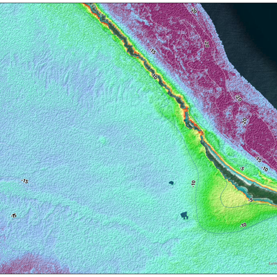
Satellite-Derived Bathymetry
In the past, bathymetry involved on-site collection techniques that made projects costly, time-consuming and unwieldy for many organizations. But with recent advances in technology and the development of satellite derived bathymetry, gathering water-depth data is fast, accurate, and reliable. Performed remotely, SDB also eliminates environmental impact, mobilization costs and risk to personnel, vessels, and equipment. TCarta produces SDB in diverse and remote environments, providing data for shallow-water regions that are difficult or impossible to access via traditional survey vessels. Delivering SDB quickly at a fraction of traditional surveying costs, we serve governments, international hydrographic offices, engineering firms, environmental organizations, and many other customers.
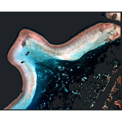
Seafloor Classification
To help organizations understand and track changes in coastal habitats over time, TCarta offers a seafloor classification products derived from high resolution multispectral and hyperspectral satellite imagery. The solution categorizes seafloor elements into classes – including coral, sea grass, mangroves, dredged areas, unconsolidated sediments, and substrate – to produce highly detailed maps for ongoing monitoring purposes. TCarta delivers seafloor classification solutions customized for each customer’s project size, budget, and final application. Connect with a TCarta representative today to get a custom scope.
Satellite-Derived Water Quality
TCarta analyzes satellite imagery to gain insight into water quality, offering a more sustainable and repeatable alternative to traditional methods of gathering data in fragile marine environments. Producing time profile graphs from the imagery allows organizations to understand changes in a marine area over time and fill in historical data gaps
Global Bathymetry GIS
An industry leader in providing customized bathymetry solutions, TCarta offers data packages designed to meet individual client needs and requirements. Employed in a wide range of applications, our data products stream directly into GIS and modeling workflows, requiring minimal effort from end users.