Water Insight services
CoastObs - Coastal water quality monitoring services
Commercial service platform for user-relevant coastal water monitoring services based on Earth observation. CoastObs is an EU H2020 funded project that aims at using satellite remote sensing to monitor coastal water environments and to develop a user-relevant platform that can offer validated products to users. Whereas traditional in situ sampling is insufficient to characterise the highly dynamic coastal environments, Earth Observation (EO) provides a synoptic view and frequent coverage. CoastObs will further develop methods to derive parameters from Earth observation satellites that are relevant for coastal management including monitoring of seagrass and macroalgae, phytoplankton size classes, primary production, and harmful algae as well as higher level products such as indicators and integration with predictive models.
Eomores - Water quality monitoring services for inland waters
Earth Observation-based Services for Monitoring and Reporting of Ecological Status. Algae, plants, health impacts, ecosystem assessment, spatial planning, event characterization, spatial planning, policy and water resource management, all based on earth observation, innovative in situ measurements and ecological modelling. Download the product and service portfolio here: https://eomores.eu/wp-content/uploads/2020/01/2020_01_13_Product_portfolio_small.pdf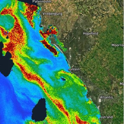
HAB monitoring - Early warning for potential harmful algae blooms
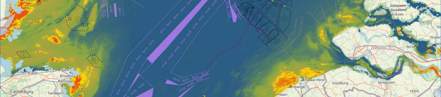
Coastal upwelling events are commonly associated with harmful algae blooms (HABs). Consistent strong winds (over days) will cause the drift of the warm nutrient depleted surface water. In its place cold water, rich in nutrients water will surface. This causes ideal circumstances for HABs to grow. The wind direction will determine where the blooms will move. This is of importance for both ecological and economical reasons. Water Insight has developed an early warning service for HABs, based on the automated detection of upwelling events and high concentrations of algae. This service helps mussel farmers to mitigate in time.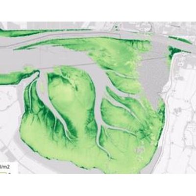
Monitoring in turbid coastal waters - Operational Service
Water Insight developed an operational service for water quality parameters based on Earth observation in the Eems Dollart estuary and the adjacent Wadden Sea area. The water quality in these areas is highly dynamic in time and space, making it impossible to monitor with conventional monitoring methods in sufficiently high resolution and frequency. Earth observation can provide a valuable contribution to an integrated monitoring system. As many standard Earth observation products and algorithms are not suitable for the very turbid and dynamic waters of the Eems Dollart region, careful validation and calibration of algorithms with in situ measurements from the area was required. The result is a service delivering relevant parameters for the calculation of primary production, including an estimate of the accuracy of the products delivered.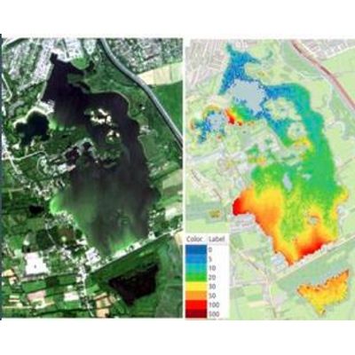
Cyanobacteria monitoring services
Water Insight can help you to quickly identify blooms and scums of potential harmful cyanobacteria. Due to climate change, cyanobacterial blooms increase in occurrence and size. They can cause ecological damage, but are also linked to public health issues. As a result, bathing waters are temporarily closed due to these blooms, hampering the tourist industry. A combination of spatial mapping areas where blooms might occur and automated-high frequency in situ monitoring with the WISPstation allows water authorities can track cyanobacterial blooms more effectively, and by taking timely measures reducing ecological effects and economic damages to a minimum.