

- Home
- Companies
- Cambridge Environmental Research ...
- News
- Street-scale pollution maps for Ireland ...
Street-scale pollution maps for Ireland now available
Results from CERC`s modelling of street-scale air pollution in Ireland have been published as part of the Irish Environmental Protection Agency (EPA) report `Air quality in Ireland 2022`. The full CERC report with high-resolution maps for a wider range of regulated air pollutants is also available. The predicted concentrations were evaluated with measured concentrations with generally good performance for both years at all site types, meeting the FAIRMODE model quality objectives. Modelled concentrations were compared to current Irish air quality standards air quality standards, with exceedances generally associated with the major road network. Most of Ireland meets the World Health Organisation (WHO) guideline for annual average NO2 concentrations, with exceedences in urban areas, while a substantial proportion of Ireland does not meet the lowest guideline for annual average PM2.5 concentrations.
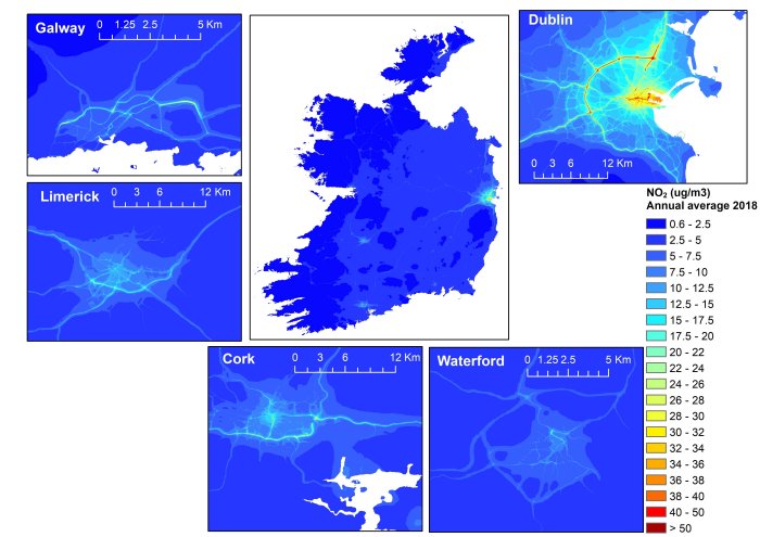
CERC were commissioned by the Irish EPA to provide street-scale modelling of Ireland for 2018 and 2019. This used the Multi-model Air Quality System (MAQS) coupled system (developed by CERC) to link regional scale hourly pollution predictions from the EMEP model with local ADMS-Urban modelling. The UK Centre for Ecology & Hydrology (UK CEH) ran the WRF mesoscale meteorological model and EMEP chemical transport model with 1 km horizontal grid resolution over Ireland. CERC carried out detailed road traffic emissions calculations in EMIT based on traffic flow data supplied by the National Transport Authority (NTA) and Transport Infrastructure Ireland (TII). Gridded emissions from non-traffic sources were obtained from the MapEire inventory.
Street canyon effects on dispersion were included in major urban areas. Three major road tunnels were also included in the modelling using the ADMS-Urban tunnels module, with high concentrations noticeable around the portals of the Dublin Port tunnel. The model output is at hourly temporal resolution and irregular spatial resolution. The MAQS PostProcessor utility was used to calculate annual average and high percentile hourly concentrations on regular grids for plotting, at 20 m resolution for whole country maps and 5 m resolution for individual cities.
The 2019 mapped concentrations were uploaded to the recent FAIRMODE composite mapping exercise, which combines and assesses modelling results for different parts of Europe. Preliminary results from this exercise were presented in October 2023, with CERC`s modelling results showing good performance in the `high resolution, unassimilated` category. Presentations describing the Irish emissions inventory development and coupled system modelling were given by CERC at the 2023 ADMS-Urban and ADMS-Roads User Group Meeting.