

- Home
- Companies
- Alberding GmbH
- Products
- Alberding - Model A08-RTK GEO-MICHEL - ...
Alberding - Model A08-RTK GEO-MICHEL -Handheld System for High-Precision Satellite-Based Positioning
The Alberding A08-RTK GEO-MICHEL® is a powerful and scalable L1/L2 Handheld-RTK-System for high-precision satellite-based positioning. Under suitable conditions, the integrated multi-frequency GNSS RTK receiver provides coordinates of the receiving antenna accurate to the centimeter after only a few seconds.
During system development, great importance was attached to compactness and ease of operation. By pre-configuring the sensor, the measurement can be started by simply pressing a button. GNSS correction data dial-up is automated via the integrated 4G LTE modem and Ntrip client software.
The positions, which are accurate to the centimeter, can be stored internally or transferred wirelessly in the standardized NMEA format to a smartphone or tablet for further processing with an app. Real-time transmission of positions via mobile radio to a server is also supported.
Information about the measurement process is provided to the operator via LED and the very easy-to-read e-paper display. The function button (Fn) can be adapted to the tasks (e.g. saving and sending positions or recording raw data) on the software side.
The GEO-MICHEL® was primarily developed for users outside of surveying who need to record precise positions quickly, easily and cost-effectively. With a suitable GNSS antenna on the rover pole, surveyors can also benefit from the system.
- Compact and user-friendly L1/L2 Handheld-RTK-System
- Real-Time Kinematic (RTK) firmware
- Easy attachments for smartphone, tablet and GNSS rod
- Low sensor weight (approx. 300 g without GNSS antenna)
- E-paper display for providing system information
- Can be used without external control unit (precise IoT, robotics)
- Configurable data flow, configuration change via internet
- Integration of low-cost or high-end RTK modules
- Flexible GNSS antenna solutions (helix or patch antennas)
- Alberding ALPOS® service with m2m SIM card and support
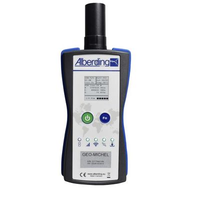
On the front of the A08-RTK GEO-MICHEL® are the e-paper display for providing system information, the on/off button, the function button and the five status LEDs. The GNSS antenna is mounted on the top and a USB-C interface is installed on the bottom. A universal holder is mounted on the back. With the corresponding counterpart, the receiver can be easily attached to a smartphone, tablet or GNSS antenna pole.
The Alberding A08-RTK GEO-MICHEL® is ideal for GIS data acquisition and surveying precisely because of its compactness and user-friendly operation. By pre-configuring the sensor, the measurement can be started with a simple push of a button and stored internally or transferred wirelessly in the standardized NMEA format to a smartphone or tablet for further processing with an app. The Handheld-RTK-System dials in to the correction data service independently and automatically. The universal holder on the receiver allows the Handheld-RTK-System to be used variably with a smartphone or tablet.
In other system variants, the Alberding A08-RTK is also suitable for applications in the field of machine control, the positioning of mobile objects and other IoT applications.