

Alberding - Model A10 -Sensors for Precise Satellite Positioning System
The Alberding A10-RTK sensor is designed for precise satellite positioning system applications. Based on a scalable GNSS L1/L2 board, the A10-RTK supports high performance heading determination using all four GNSS systems.
In addition to an integrated Cortex processor, the A10-RTK sensor has a Linux board, which is used for the integration of application software. Sensor fusion, data conversion, geofencing or geomonitoring algorithms can be run directly on the A10 sensor, so that, for example, alarms can be sent directly from the A10-RTK.
The multi-port connector of the A10-RTK provides various interfaces (serial, USB, Ethernet, CAN bus, etc.) that can be used, for example, for integrating the system on agricultural and construction machinery. RTK positioning, project data transmission and machine data collection - one system for many applications.
- Dual-frequency GNSS board.
- Integrated storage of RTK positions and raw data.
- Server/Client communication (LTE module).
- Integrated Bluetooth module.
- Integrated Cortex processor for data management.
- Embedded PC with Linux operating system (optional).
- Integration of application software.
- Customisable configuration.
- Automatic data transfer.
- Autonomous operation through preconfiguration.
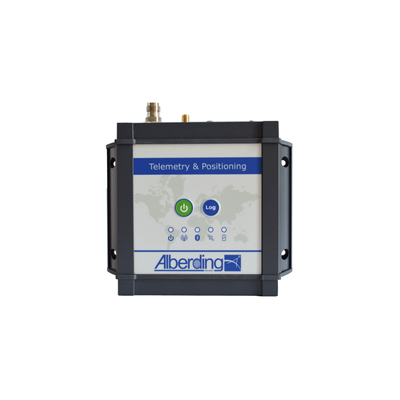
On the top side of the A10-RTK sensor, you can find the power button, the log button and five LED status lamps. The following ports are available on the front panel: GNSS antenna, GSM antenna, as well as a serial port (Sub-D HD26).
One system - multiple applications
The integration of an embedded PC in the A10-RTK sensor is the key to flexible system customisation for diverse digitisation and automation tasks. While the integrated microprocessor controls the data transfer in the A10-RTK sensor, the software can perform more extensive calculations on the embedded PC. Currently, both software solutions from Alberding GmbH (e.g. EuroRef and EuroNet) and third-party software (e.g. BNC from the Federal Agency for Cartography and Geodesy and SSR2OSR converter from Geo ++ GmbH) are supported.
- Autonomous GNSS reference and monitoring station
- RTK correction data provision
- Monitoring of RTK services in the field
- Enhanced GNSS rover functionality
- Support of two different IP address domains, one for RTK correction data and another for GNSS positioning data
- Switching between two correction data sources (e.g. mobile Internet and radio data transmission in the 70 cm band)
- Integration of GNSS algorithms
- GNSS data conversion (SSR→OSR, DataConv)
- GNSS positioning algorithms (BNC, RTKLib)
- Monitoring objects, buildings and embankments
- Geomonitoring in engineering technology
- Geofencing, machine monitoring
- Sensor fusion
- Combined data acquisition from GNSS and external sensors (EuroNet)
- Combined analysis of GNSS and external sensor data
- Project data transmission
- Transmission of engineering project data (digital terrain model, station coordinates)
- Transfer of agricultural management data (site-specific fertilisation)
- Telemetry module with RTK
- Data retrieval and transmission from agricultural and construction machines
- Combination of telemetry and RTK