
Arktis Radiation Detectors Ltd.
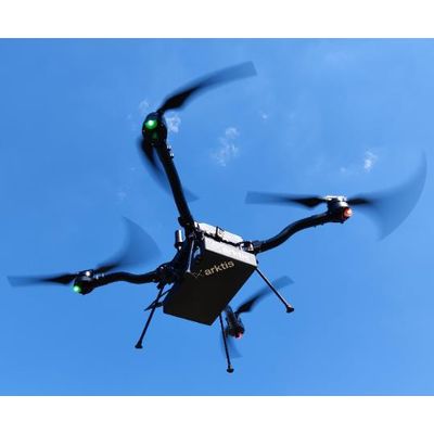
Arktis - Radiation Detector Drone
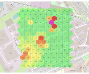
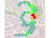
Uncrewed Aerial System (UAS) for radiation mapping and source search. This radiation detecting drone can map an area of 10’000 m2 in a single flight of 20 minutes. The system is about 50 x more sensitive than typical drone-based detectors.Most popular related searches
naturally occurring radioactive material (NORM)
radiation detection system
naturally occurring radioactive material
radiation detection
contaminant mapping
contamination mapping
radioactive source locating
gamma detection system
radioactive contamination
gamma area monitoring
Flying a tight search pattern, it can map radiation at speeds of 2 m/s. Equipped with a large area Flat Panel Gamma (FPG)
detector, the system can rapidly find and localize radioactive sources.
This tool is indispensable to prepare for– or react to – a reactor accident, locating stolen radioactive sources or inspecting bulk goods for excess radioactivity.
Best-in-class performance
- Large area detector (300 cm2) with very high sensitivity
- Unbeatable for large area search missions
- Spectral distinction between artificial sources and Naturally Occurring Radioactive Materials (NORM)
- LIDAR-based altitude measurement enables precise altitude compensation and ground projection of dose rate
- Minimal power consumption allows 20-minute missions per battery
Ease of operation
- Minimal setup time
- Computer assisted mission planning allows rapid deployment with minimal training
- Mission control software has intuitive Graphical User Interface (GUI) for flight control, data taking and analysis
- Outdoor and indoor (IP54 or better)
- Interoperable with Arktis and 3rd party systems
“Finally an airborne detector sensitive enough to rapidly deliver high count statistics”
Typical applications include
- Wide area search for radioactive sources
- Contamination mapping
- Defining exclusion zones following radiological incident
- Venue profiling in preparation of large events
- Targeted primary screening of vehicles, boats, small aircraft