

- Home
- Companies
- Egis Group
- Products
- EGIS ProfiTracker - Model XL - Bi-Axial ...
EGIS ProfiTracker - Model XL -Bi-Axial Antenna Positioning System
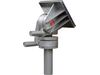
The Profi Tracker XL is an advanced antenna positioning system designed for precision alignment and tracking of satellites, catering to technical environments such as broadcasting centers, meteorological stations, and research institutes. It's capable of both geostationary and low Earth orbit satellite tracking using sophisticated algorithms for auto-focus and auto-tracking. The system features a robust azimuth-elevation rotation mechanism with a 360° azimuth and 90° elevation range, ensuring comprehensive satellite coverage. Equipped with an RS 232 C data interface, it allows seamless integration with external computers for real-time telemetry and control, including GPS-based automatic position detection. The rotor unit is housed in weatherproof steel, delivering high precision and durability. Its built-in spectrum analyzer aids in selecting specific transponders for optimal signal acquisition. The system's user-centric design supports extensive programmability via a 16-bit microcontroller, enhancing its adaptability across diverse applications.
|
For communication companies, broadcasting centres, meteorological stations, press- and multimedia editorial offices, research institutes and educational establishments, VSAT, SNG, radio relay transmissions. When prospective customers learn about this new antenna positioner, they suppose a tuned, high scale copy of our longstanding product Profi Tracker CL. This is only partly true. The new â€�ProfiTracker XLâ€, however, can do more: Our objectives for the new design were
|
What do the capacities of the new product look like?
- Exceptionally easy and fast installation, and yet a highly accurate alignment due to the utilization of one motor each for the angle of altitude (elevation) and for the horizontal rotation (azimuth), combined with a high speed positioning computer
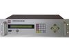
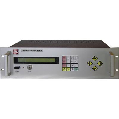
- Full equipment: The system includes an external unit (rotor) and an internal unit (operating panel with power supply)
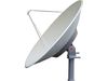
- Safe for antennas up to 3.7 m in diameter
- Given this maximum size, the antenna still allows for 180 km/h wind speed!
- Stylish appearance due to distinctive industrial design
- High degree of operating convenience achieved by pre-programming all geostationary satellites currently existing around the globe! Thus the rotor system is subject to the physical limits - instantaneously applicable on all continents, no matter whether you are south or north of the equator!
- Name and position of each pre-programmed satellite are displayed.
- Safe for the future, with 400 SAT-memory places, which can be individually changed, re-allocated or deleted by the operator.
- It can be predetermined for each satellite, whether, once the satellite has been dialled-up, one Autofocus-run is to be performed automatically or, e.g. at inclining satellites, a permanent auto-tracking runs or only one single positioning is done.
- Best information and feed-back during programming and everyday-operation via a well-lit 40 digits-plain-text-display.
- All programming and adjustment operations can be remote-controlled from the location of the receiver and the control unit!
- Sophisticated electronics allow for best and most accurate adjustment to any existing system (see advanced programme list).
- All data and settings are secured for years against electrical power outage by a long-life backup battery
- Important data and settings are password-protected
- Besides AUTO-FOCUS and AUTO-TRACKING there is SUPER-SEARCH making life much easier
- Particularly suitable when using several LNBs, (C-, Ku-, S-Band und Yagi-antennas) having each its own feed. The optimal focal point of each Feed for both axes can be memorized individually!
- With hardware-extension, clock inclusive of calendar and astronomical sun-tracking-program to prevent the risk of LNB-burnout or LNB-melting, when the formation "sun-satellite-parabolic-antenna in one line" appears. This system permanently compares the current position of the sun to the AZ- and EL-angles of the target- satellite. If there is any danger the LNB could be destroyed by direct centric sun-radiation, the system raises an alarm. The user can determine by pre-programming, how many minutes before the event a notification should be delivered, whether the position will be automatically quit for a short period after a set time, or whether the transmission shall not be interrupted and the position be kept continuously.
- The wind-sensor-interface is provided to connect a pulse-giving wind-anemometer to the 4-wire-interface. After having entered pulse per time unit of the wind-sensor and after reaching the wind-speed-threshold preset by the user, the system automatically turns to a preset, more streamlined position. The delay time in this position in this position is programmable as well.
- Fully automatic operation, due to automatic start-up in case of power failure
- Typical range of application: Communication companies, broadcasting centres, meteorological stations, press- and multimedia editorial offices, research institutes and educational establishments, offshore oil rigs, VSAT, SNG, radio relay transmissions and many others.
COMMUNICATION INTERFACE
For communication with an external computer, the system is supplied with a serial two-way «RS 232 C data-interface» (data stream: 8 bit / no parity/ 1 stop-bit / 50 to 9900 baud with hardware-handshake). Can be used to advantage for: Alignment to and tracking of non geostationary objects, such as stars (astronomy), space stations (ISS), amateur radio- satellites (OSCAR) and for low-flying LEO-satellites, respectively those with elliptical orbits.
Direction-defining data are transmitted to the rotor-control via a «RS 232 C data-interface». This works in the opposite direction, too: You may at any time recall information about the rotors operating status from the computer. The intelligent interface also allows for operation via telephone-modem. Built-in filters make it possible to operate several rotors at a single interface.
Also suitable for field-strength depending alignment to and tracking of measuring signals, e. g. meteorological probes (weather balloons), radio direction finding of locating movable transmitters. The measuring directions and the field strengths are permanently transmitted to the external computer via data-interface!