

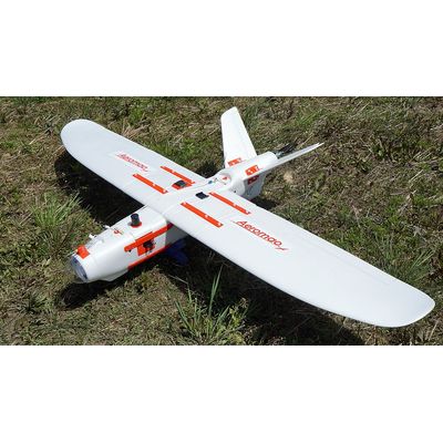
Aeromapper Talon LITE - Commercial Fixed Wing Drone
The Aeromapper Talon LITE offers the lowest cost per surveyed acre, guaranteed. The Aeromapper Talon LITE is an affordable commercial fixed wing drone designed to keep your data collection & operational costs as low as possible, providing the maximum return on investment. With an impressive flight endurance of up to 2 hours and 45 minutes the user can maximize the area mapped in each surveying session. Starting at $6,900 USD, the Aeromapper Talon LITE can autonomously map up to 11Kms2 (2,718 acres) per flight, thanks to its new LiIon battery technology. This is more than twice the area coverage per flight than the leading brand of fixed wing drones, but at a fraction of the cost.
We have a wide range of payloads available, including 24 and 36 Mp RGB, Reach M2 PPK UAV Mapping kit, Micasense Rededge & Altum, HD Video-downlink and Thermal sensors. This professional UAV system is completely modular, customizable and ideal for applications such as surveying & mapping, conservation, forestry, inspection, oil & gas, agriculture, surveillance and scouting.
- Up To 2:45 Min Endurance
- Reach M2 PPK Mapping system
- Fully Autonomous
- Air traffic awareness
- Long Range Links (+30Kms)
- Unmatched productivity per acre
The Aeromapper Talon LITE is built for professionals who need dependability, accuracy, ease of use and low cost on their operations. This fixed wing drone facilitates this by offering great performance, payload versatility and uncomplicated launch and recovery procedures. If your operations need a parachute equipped drone for recovery in tight spaces we suggest the Aeromapper Talon standard.
Its proven long-range communications system enables users to fly as far as 30kms away from the Ground Station, making it ideal for BVLOS missions (Beyond Visual Line of Sight) and large-scale area mapping.
NEW! The Aeromapper Talon LITE is now equipped with ADS-B: the drone reports live the location and altitude of nearby manned aircraft so all operators can safely share the airspace. Works to a radius of up to 100km.
The Aeromapper Talon LITE is based in our super-successful Aeromapper Talon, a proven UAV system currently operating in more than 50 countries since 2014, accumulating thousands of flight hours, from hot desert & tropical climates to the toughest artic conditions around the globe.
Incomparable productivity per flight: The Aeromapper Talon LITE can map up to 11 sq.km (2,718 acres) @125m (400ft) agl in a single flight, offering the best area coverage on the market.
Thanks to its impressive endurance and long-range communications link, the Aeromapper Talon LITE is the absolute best data acquisition drone to tackle those very large projects that require centimeter accuracy when ordered with our Emlid Reach M2 PPK UAV Mapping kit. The PPK system eliminates or greatly reduces the need for GCPs and let you achieve centimeter accuracy easily and with minimal costs. The system includes the Reach M2 GNSS receiver installed onboard the aircraft and the Reach RS2 multi-band base, all delivered ready to capture accurate data.
The ideal tool for surveying and precision agriculture when used with any of our multispectral camera options available, Micasense Readedge MX or Micasense Altum. As manufacturers we can custom-install other brands and makes of sensors and cameras.
The Aeromapper Talon LITE is equipped with an ADS-B system for live air traffic data reporting, allowing the drone operator to receive flight information from manned aircraft within a 100km radius. The system receives information such as position, altitude, speed, trajectory and displays it in real time in the Mission Planner flight management software in real time.
The Aeromapper Talon LITE automatically belly lands perfectly every time, even in strong crosswinds. Minimum area required for an automatic belly landing is 100m long x 7m wide. Requires a path clear of obstacles to perform the approach.
Keep a constant eye in the sky: add our new Eyeshot Pro real time video system to patrol very large areas. Ideal for situational awareness, inspection, wildlife observation, surveillance, environmental monitoring, infrastructure monitoring, scientific research, among others.
Field proven BVLOS capabilities thanks to its rock solid long range communications link: fly with confidence as far as 30km away from the operator.
Simple and uncomplicated setup and operation. Setup in 5 minutes and fly the mission completely autonomously. Every unit manufactured in our headquarters in Canada is individually flight tested before shipping.
- Construction: EPO foam (durable, easy to repair, carbon fiber reinforced).
- Wingspan: 2 m.
- Weight:3,100 grs.
- Endurance:2 – 3 Hours in standard configuration (depending on payload selection).
- Launch:Very easy to hand-launch.
- Landing: Automatic belly landing.
- Maximum payload: 480 grs.
- Communications link range: +30kms. Tested in real BVLOS flight operations (Beyond Visual Line of Sight).
- Max. Altitude: About 4500 masl.
- Cruise speed: 48 Km/h.
- Flight modes: Manual, Stabilize, Return to Home, Fly be Wire, Auto.
- Wind Tolerance: up to 35 km/h. for flight and autonomous belly landing.
- Maximum speed: +90 Km/h.
- Failsafe: Automatically returns to home & loiter upon loss of RC link. Other failsafe routines available.
- Telemetry: Battery status, alt, ground speed, compass, attitude, distance travelled, time on air (speech enabled), and more than +200 parameters more.
- Moving map display / telemetry: Drone position and heading, commands on map, fly to point on map, altitude changes, remote spot camera trigger, mission route, and more.
- Weather: -20°C to +40°C
- Aeromapper Talon LITE Unmanned System Ready to Fly.
- One LiIon battery pack & charger.
- 30 Km Telemetry Link system.
- ADS-B live air traffic data system.
- User’s Manuals & Documentation.
- Heavy duty carrying case.
- Unlimited support.
- Mission Planner Software.
*Payload available separately
*Carrying case available separately