

Delair
Delair - Model UX11 Ag -Plant Mapping Drone
FromDelair
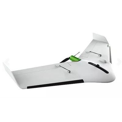
The Delair UX11 Ag: high productivity and easiness of use with no compromise on the data quality - for professional ag insights. The Delair UX11 Ag is a plant mapping drone capable of onboard data processing and with wireless and 3G/4G communications. Thanks to its PPK-as-you-go feature it is possible to precisely overlay maps for temporal analysis and on the route planning and guidance for on the ground agricultural machines. Now you can collect plant aerial intelligence more accurately and efficiently and reach a new level of productivity.
Most popular related searches
High-end multispectral camera for plant level measures
Embedded aerial intelligence
- Real-time camera to Ground Control Station link for on-the-fly quality control
- Control camera settings and quality during flight
- Fully-integrated Micasense camera
- 8 cm GSD at 400 ft (122 m) flight height, down to 5 cm GSD
Future-ready electronics
Embedded system with onboard processor:
- Advanced quality checks on the fly
- Deep learning
- More to come!
- Endurance1 Up to 52 min
- Weight 1.6 kg (3.52 lbs)
- Deployment time 5 min
- Cruise speed 54 km/h (33.5 mph)
- Take off / Landing Hand-launched (angle: 30 degrees) / Belly landing (angle: 30 degrees)
- Flying range1 47 km (29.2 mi)
Communication range
- 3G / 4G Unlimited (within network coverage)
- Optional radio link1 FCC up to 10 km (6.2 mi)
- CE up to 5 km (3.1 mi)
Sensor
- Image Resolution GSD down to 5 cm
- Sensor type Global shutter, distortion free