

- Home
- Companies
- Landviser, LLC
- Products
- Landviser - Model Geovizer - ...
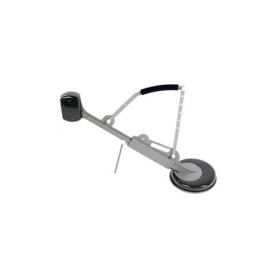
Landviser - Model Geovizer -Electromagnetic Multi-frequency Sounding Device
Geovizer designed to study the top three meters of the Earth’s crust. The real depth of measurement depends on the resistivity of the ground, however, can’t exceed 3 m on real grounds because of the limited sensibility of receivers. Meanwhile, we can expect that in some special kind of media such as dry sands or ice the propagation depth can reach and even exceed 4 m.
The device can operate on 3 frequencies. It means that the data acquired can describe the geoelectric situation at 3 levels of depth.
In the horizontal plane, the responding media is the ellipse with one constant axis length (0.7 m) and second axis length depending on the frequency 0.5 –3 m.
Having such a resolution we can basically state that the unit is intended for 3D specification of geoelectrical parameters of the media at a depth up to 3 meters with heterogeneous inclusions dimensions 0.5 x 0.5 x 1 m or more. Meanwhile, the very contrast targets such as metal objects can be even smaller.
- Archaeological survey;
- UXO determination;
- Subsurface tunnels and empties investigations;
- Quantitative assessment of water saturation of the ground;
- Assessment of HC waste in the ground;
- Searching both fresh and salty water source;
- Subsurface buildings condition control;
- Searching and localization of burial place of industrial waste;
- Source and volumes of water leakage in water supply and heating systems;
- Source and volumes of fuel/oil leakage in subsurface fuel tanks/pipelines;
- Definition of places of a lining of metal pipes and cables.
- Frequency range: 12.5-111 kHz;
- Transmitter power (impulse): 60 W;
- Receiver sensitivity: 1 mV;
- Scan time for a single point at 3 freqs: 2 sec (or any set from 1-14 deferent frequencies);
- Noise level: 50 nV;
- Dimensions: 90?75?25 cm
- Battery operation time: 8 hours;
- Weight: 5 kg.