

- Home
- Companies
- Ian AR Hulbert AS
- Products
- FLiteTraX - Model ULTRA 5G P1 - GPS 5G ...
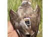
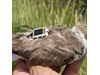
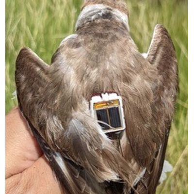
FLiteTraX - Model ULTRA 5G P1 -GPS 5G & BLE Tag 2.6g
FLiteTraX ULTRA is an ultra-light, solar-powered GPS tag designed for avian tracking, weighing just 2.6 grams. Utilizing the latest in 5G cellular and Bluetooth (INTELINK) technology, it offers seamless data transmission to mobile phones or Bluetooth gateways, with data subsequently uploaded to a cloud server for easy access via a web link. The device supports both NB-IoT and LTE-M frequency bands, ensuring broad compatibility and reliability. Technical specifications include a 15 mAh lithium polymer rechargeable battery with extensive GPS position tracking capabilities, and durability is ensured by a titanium alloy body with an IP68 rating. For researchers, INTELINK technology extends device functionality to include firmware upgrades, remote data downloading, and raw acceleration data collection, providing a comprehensive solution for ecological and behavioral studies.
FLiteTraX ULTRA is tiny Solar powered GPS tag that uses the 5G cell phone network and long range Bluetooth (INTELINK) to transmit data directly to a mobile phone or to a Bluetooth gateway. Data is uploaded to the cloud server and is accessible to the user through a web page link.
Data upload ULTRA 5G
ULTRA 5G supports both NB-IoT and LTE-M (or called eMTC) frequency bands. We will activate selected bands for devices to be used in different regions.
Data upload ULTRA BLE Intelink
- Transmission method: INTELINK based on Bluetooth 5.0
- Maximum uplink/downlink speed: 1 Mbps/1 Mbps
- Output power: 8 dBm
- Transmission distance: 80~120m with ordinary smart phone; up to 1200m with Debut series gateway products.
EXTRA FUNCTIONS brought by INTELINK
INTELINK® technology enables remote connection to your MINI (Argos) devices to perform various operations and realize many amazing functions.
To establish such connection, you only need an ordinary smart phone or/and a Debut series gateway device.
*Debut gateways could be a HUB, TAG or QUEST. The connection distance is 30~200m depending on environment.
Tracker Recovery
With ECOTOPIA App, a device and a mobile phone will automatically function as a beaconsystem. The mobile phone will ring if the device is detected nearby. The closer they are, thelouder the ringing sound will be. This provides a convenient way to find lost devices.
Firmware Upgrade & Setting Modification
You can easily upgrade the firmware or change data collection settings and Argostransmission schedules for a device nearby using Ecotopia App.
Remote Data Downloading
MINI (Argos) is capable of collecting much more data than the Argos transmission throughput limitation.
If the bird wearing MINI (Argos) device flies to somewhere near a Debut gateway*, the data stored in the device memory can be automatically downloaded and sent to the cloud server via network connection of the HUB. Then, the researcher can see the data in theiraccounts.
Raw Acceleration Data Collecting
Raw x/y/x acceleration data could be very useful for behavioral research, especially whenthe data can be combined with timestamps, GPS, environmental data, and the bird’sactivity rhythm. However, the raw data can seldom be obtained due to its large size.
With INTELINK, you can not only download the raw data from memory, but also obtain real-time raw acceleration data by connecting a mobile phone to a MINI device.
In-situ Modeling
During the process of obtaining real-time raw data described as above, you can also markthe data with behavior tags. Ecotopia App provides comprehensive tools for In-situmodeling, which includes real-time x/y/z acceleration visualization and data downloading,video shooting, and behavior tagging. All these data will be combined under thetimestamps and saved for later verification and analysis.
With the help of Druid’s AniAct® behavior algorithm platform, you will be able to generateacceleration-based behavior algorithm for different species.
Furthermore, such algorithm can be loaded into the tracker and be conducted on board.Then, the tracker will be able to send back continuous computed result of behavior tagsinstead of discontinuous raw data. This will expand the data dimensions and bringbreakthrough on bird research and ecology conservation.
- Weight : 2.6±0.1g
- Dimensions : 17 mm x 12 mm x 8.5 mm
- Working Temp : -10°C~60°C
- Batttery : 15 mAh lithium polymer rechargeable battery, with under-and-over-charging protection
- Battery Life : Over 100 GPS positions under optimal GPS satellite view at 5-minute interval
- Solar Type : GaAs solar unit (30% efficiency) with good performance under weak light
- Antenna Material : Titanium alloy with protective coating
- Attachment : Two through holes at two ends, respectively for harness, or glued-on
- GPS Module : Precision: CEP(50%)5m
- Maximum update rate: 10 Hz
- Waterproof : IP68
- Firmware Upgrade : Remotely via network, or instantly via INTELINK
- Working Scheulde : Remotely via network, or instantly via INTELINK
- Data Storage : Logged data will be stored in memory if network is unavailable.
- Flash memory: 16 MB
- Regular data storage: 460 days at default setting (1h GPS+1h ENV+10 minBHV)
- BOOST data storage: 280,000 pieces
- ACC data storage: 28,700 pieces