
- Home
- Companies
- Blue Aspirations
- Products
- Blue Aspirations - Model BA-FLS-NX5 - ...
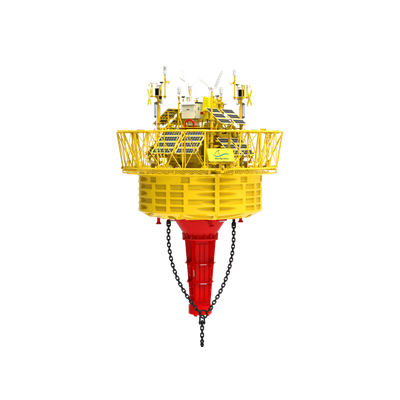
Blue Aspirations - Model BA-FLS-NX5 -Floating LiDAR System for Offshore Wind and Metocean Measurements
The BA-FLS-NX5 is a cutting-edge floating LiDAR system developed by Blue Aspirations, designed to collect wind and metocean data essential for the feasibility assessment and critical decisions in the development of offshore wind farms. This advanced system integrates multiple LiDAR models, including WindCube V2 Offshore, ZX 300M, and dual Molas B300M, achieving Best Practice of OWA Stage 2. It provides comprehensive solutions for preliminary wind farm resource surveys and decision-making in design and investment evaluations. Equipped with advanced encryption and secure data storage, this system assures high reliability through dual LiDAR configurations, continuous and pulse wave technologies, and motion compensation algorithms. Its robust structure offers high survival rates and redundancy through dual AIS systems and navigation lights. Power is continuously supplied by solar panels, wind turbines, and optional fuel cells. Customizable mooring options ensure adaptability to various marine environments with continuous position monitoring.
Now BA-FLS-NX5 is the world`s first wind and metocean measurement system that has reached the Best Practice of OWA Stage 2 for 3 different LiDAR models. The verified LiDAR configurations include both WindCube V2 Offshore and ZX 300M, and dual Molas B300M LiDARs.
- To provide complete solutions for the preliminary resource survey of wind farms
- To provide critical decision data for wind farm design and investment evaluation to improve investment certainty
- To provide data services for marine meteorological monitoring and forecasting
- To provide data support for marine disaster forecast warning modeling
- Abidance by international HSE standards
- Data is encrypted for transmission and securely stored in the customer`s local server
- Dual LiDAR system with both continuous wave and pulse wave LiDARs
- Full redundancy to eliminate single-point failures
- High raw data quality from specific buoy design
- State-of-the-art motion compensation algorithm
- Multiple third-party reports with OWA Stage 2 Best Practice
- Post-processing TI data with Best Practice
- High survival rate after collisions, and structure design with multiple cabinets to prevent sinking if any water ingress
- Proven track records of extreme weather experiences (violent storms, high temperatures, freeze and snow, rainy season, etc)
Floating platform
- Diameter: 5m
- Height: 9m
- Mass: 15t
- Net buoyancy: 10t
- Structure: multiple cabinets
- Dual LiDAR(by default)
- ZX 300M, Windcube V2 Offshore, Molas B300M
- Temperature, humidity, and atmospheric pressure
- Rainfall, solar radiation
- Wind speed and direction
- Wave (significant wave height, one-tenth wave height, maximum wave height, wave period, mean wave period, zero-crossing wave period, wave direction)
- Current speed, current direction
- Water depth/water temperature/salinity
- Bird and bat monitoring
- Sea mammal and fish monitoring
- Water environmental monitoring
- LAN
- Satellites: SBD SAT messaging module, other Broadband SAT data modules (optional)
- Mobile networks: 2G/3G/4G
- WiFi: 2.4GHz/5GHz*2
- Local ethernet connection