
Ground Penetrating Radar (GPR) Technology
GPR is an acronym for Ground Penetrating Radar, and as the name implies, it’s a radar system that you use to image the subsurface. It may be used on a host of different penetrable materials to detect and map features or objects within. The technology has been widely accepted and is routinely used for various applications such as mapping utilities, bedrock, cavities/sinkholes, archaeological artifacts, and groundwater levels. More recently, it has found use in military/ counter-terrorist, law enforcement, and search-and-rescue applications. Other common names for GPR include impulse radar, geo radar, and ultra-wideband radar.
As a safe and non-disruptive method, GPR is the ideal way to investigate the subsurface for a wide range of applications. Deploying GPR in the field is easy, and sites can be scanned rapidly, which also makes it an economical choice.
Originally pioneered as a non-destructive technique for geophysical investigations, GPR can be used to obtain information about what lies beneath the earth’s surface and to non-destructively detect and map both natural geological features and buried man-made infrastructure.
- Safe - non-intrusive and non-disruptive
- Efficient - quick to deploy, easy to operate, with rapid results
- Versatile:
- works through any penetrable media
- can detect both metallic and non-metallic objects/ features
- only requires single-sided access to investigate man-made infrastructure

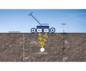
GPR works by transmitting a small pulse of ultra-wide band (UWB) electromagnetic energy into the material under investigation and then records the time it takes for some or all of that energy to be returned, along with a measure of its signal strength.
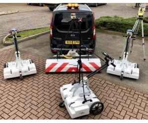
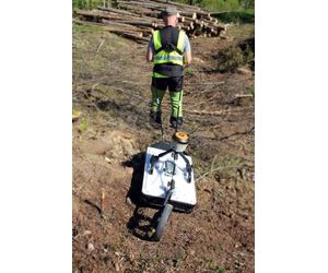
A GPR antenna, which contains both transmitting and receiving elements, is placed on, or very near to the surface of the ground (or material under investigation), and moved across it to scan the area.
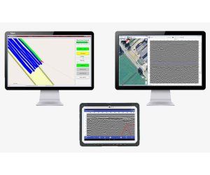
By continuously transmitting pulses and recording the associated returns, a radargram image of the subsurface can be generated and viewed in real-time on a suitable screen (pc/ tablet).
Changes in the composition of the subsurface can be seen based on air, mineral and water content, presence of bedrock or other geological features, and objects such as buried utility lines.
All GPR systems need to sample analogue signals from the antenna and digitize them for processing and display. The sampling method, as well as the rate at which samples are taken, can significantly affect the quality of results. Therefore, the sampling rate is an important specification that determines system performance.
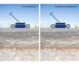
Traditionally, GPR systems utilize a technique called ‘equivalent time-sampling,’ which requires a new pulse to be sent from the transmitting antenna for every sample recorded on the receiver end. Systems using this method are commonly known as conventional GPR.
However, modern components now make it possible to use a technique called real-time sampling or RTS, and this is the method used in ImpulseRadar designs. As the name implies, it means that the ‘real’ signal is captured directly, and in sharp contrast to conventional systems, it does not require repetition of the transmission-recording cycle. The result is a GPR system that gathers data thousands of times faster than a conventional one.
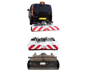
The requirement to survey over larger areas and apply 3D processing and visualization processes has led to the development of advanced GPR systems that comprise multiple GPR antennas connected to form a GPR array. The ImpulseRadar Raptor solution contains several individual antenna elements (transmitters and receivers), which are arranged to form multiple measurement channels that operate simultaneously and are closely spaced to each other.
There are several benefits with 3D-GPR surveys vs single line data collection – no loss of information, true-3D visualizations and almost photography-like images, easier to interpret due to their intuitive character:
-
The traditional approach with multiple parallel lines, sometimes in a perpendicular grid pattern, where often gathered with line spacing in the order of half a meter. Since a GPR may have a spatial resolution in the order of a few centimetres, this leads to aliasing, or in other words loss of information. When using a Raptor array, the individual line spacing will be 8 or 4 [cm]. Imagine collecting data with 4 [cm] line spacing over a few hectares, with a single channel antenna, almost undoable. In short, Raptor data is of significantly higher reliability compared to any 2D dataset.
-
The dense datasets gathered with Raptor enables a user to view data from any direction, without the interpolation artefacts seen commonly in approaches to 3D data gathering with single-channel antennas.
-
Although the Raptor system may seem more complicated compared to an ordinary GPR-system, the following interpretation is significantly easier. The 3D-processes yields photography-like images which greatly simplify the otherwise tedious work of interpretation. It becomes a very intuitive process.
A GPR array collects much more data in one pass when compared to a typical GPR system. But since the Raptor system is also based on real-time technology, surveys along each line are equally fast. Consequently, surveying extensive areas can be done more quickly and efficiently. Routine applications now include utility mapping, archaeological investigations and artefact mapping, road surveys, bridge deck investigations, and more.
Commonly known as post-processing, where the raw GPR data (as collected and saved on-site) can be managed and reviewed (off-site) using PC-based software. Processing GPR data can aid in the analysis and interpretation of results.
The practice of post-processing GPR data can often be more efficient than trying to mark-out and make decisions directly on site. Operator experience, the complexity of the site, and/ or project time constraints, may all contribute to such an approach. Typically, post-processed data is more detailed and provides more information on which to make critical decisions.
ImpulseRadar offers both 2D and 3D data processing software to support our product lines, and several third-party vendors offer GPR data processing software that supports our data formats.
ROI of up to $21 per $1 invested
The use of GPR feeds important data into subsurface utility engineering processes to improve the reliability of subsurface information and geolocation accuracy of buried utilities. There is growing evidence that the use of SUE in infrastructure projects has a positive return on investment.
U.S. Department Of Transportation
ROI of $4.62 per $1.00 invested ‘Cost Savings on Highway Projects Utilizing Subsurface Utility Engineering’ (Purdue University, 1999)
Ontario Sewer and Watermain Contractors Association
ROI of $3.41 per $1.00 invested ‘Subsurface Utility Engineering in Ontario: Challenges and Opportunities’ (University of Toronto, 2005)
Pennsylvania DOT
ROI of $21.00 per $1.00 invested ‘Subsurface Utility Engineering Manual’ (Pennsylvania State University, 2007)
University of Toronto
ROI of $2.05 to $6.59 per $1.00 invested ‘Evaluating the use of Subsurface Utility Engineering in Canada’ (University of Toronto, 2006)
The use of locating technologies such as GPR assist greatly in improving our understanding of what lies beneath the surface of the ground and other structure and increasingly shows quantifiable benefit in improving the positional accuracy of subsurface infrastructure.
Legislation & Standards
Many countries have deemed the use of GPR a mandatory requirement for such work, which is supported through the implementation of robust standards such as: AS 5488-2013 (Australia), S250 (Canada), NTE INEN 2873 (Ecuador), Malaysia Standard Guideline for Underground Utility Mapping, PAS 128 (UK) and ASCE 38-02 (US).
3D Data Capture
The requirement to survey over long distances or larger areas has led to advanced development of GPR systems that comprise multiple GPR antennas. These ‘GPR Arrays’ allow such areas to be surveyed more quickly by collecting several GPR profiles simultaneously and offer full 3D data capture. Routine applications now include utility mapping, archaeological investigations and artefact mapping, road surveys, bridge deck investigations and more.
Subsurface Utility Engineering (SUE)
GPR is a well proven non-destructive geophysical method for the detection and mapping of subsurface infrastructure. Subsurface utility engineering (SUE) professionals routinely use GPR to collect important data concerning the presence and layout of buried utilities and other subsurface assets and infrastructure.
Simplicity
An RTS systems does not require the control unit that is central to the configuration of conventional systems. Consequently, there are less cables and inter-module communications, making systems more practical and field friendly.
Survey speed
While conventional systems can rarely be used at speeds higher than 50 km/h (without increasing the point distance), an RTS system may be used at virtually any speed. This equates to quicker surveys and more importantly for road surveys, without disruption to traffic flow.
Penetration depth/sensitivity
Since an RTS system gathers data faster, this collection rate is used to lower the system noise floor, which effectively increases the signal penetration depth. To our knowledge, true 16-bit data has never been gathered with conventional GPR systems, whereas an RTS based system may easily exceed 20-bit.
Dynamic range/sensitivity
Often expressed as effective number of bits, or in dB, where 16-bits equals 96dB. This parameter has a direct impact on the penetration depth and a higher number is better.
Speed range
Nowadays, vehicles are commonly used to facilitate GPR surveys, even over rough terrain. It’s important that the speed of the GPR system matches the survey speed, otherwise the density of data must be reduced, which will compromise results.
Center frequency and bandwidth
These two parameters determine the resolution of the system, i.e. the information content of the gathered data. Higher numbers give more information, but at the expense of depth penetration.
Ease of use
Or user friendliness; not a line item you generally see since it does not directly impact results. However, over the years we’ve encountered many clients who complain about ruining a survey, due to complex settings that they’ve managed incorrectly. An RTS-based system is much more user-friendly and easier to train on and learn, so minimizes such risk.