


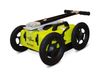

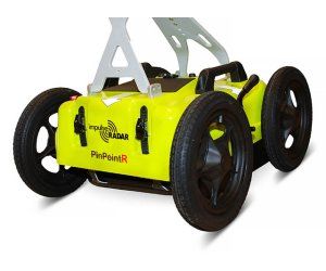
PinPointR - Ground Penetrating Radar Utility Locator
The PinPointR has been developed to maximize in-field productivity by utilizing ImpulseRadar’s innovative real-time sampling (RTS) dual-channel antenna technology, which provides incredible bandwidth, speed, and resolution, all controlled via an intuitive Android-driven user interface. The ImpulseRadar PinPointR offers a clear and dependable way to quickly and easily locate, avoid or map underground utilities with the functionality required to meet approved industry standards, whilst offering market-leading performance and data quality. Detect, Avoid and Map Underground Utilities.
ImpulseRadar Real-Time Sampling (RTS)based antenna technology
Quick, clear and dependable locates to maximise in-field productivity and decision making
Dual channel operation400 MHz (LF) and 800 MHz (HF)
One-pass locates with full depth range improves locating efficiency and decision making
Wireless data acquisition
No cables to be lost or broken which simplifies set-up and in-field productivity, and minimises operational servicing costs
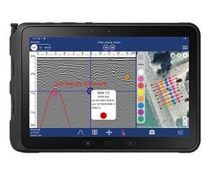
Android-driven user interface
Flexibility in choice of acquisition device
7-hour battery life
Low power consumption to extend working time
Internal GPS
Geo-referenced data as standard
Supports external GPS
Compatible with DGPS or RTK-GPS for higher accuracy geo-referencing for mapping/reporting purposes
Automatic utility report generation
Simplifies report generation and proves site visit for job/ ticket sign-off
The Android data acquisition App includes industry standard marker functionality (APWA, AS5488, or user-defined) to enable users to mark-up data in the field to correlate with the actual paint marks they put on the ground and any subsequent field sketches or report outputs.
Antenna
- Technology: ImpulseRadar real-time sampling
- Antenna type: PinPointR dual-channel
- Centre frequency: CH-1: 400 MHz (LF) / CH-2: 800 MHz (HF)
- Channel activation: CH-1 & CH-2 (LF & HF)
- Signal to noise ratio (SNR): >100 dB
- Significant/useful number of bits: >16 bit
- Scans/second: >800
- Survey speed: > 130 km/h @ 5 cm point interval
- Time window: 388 ns (LF) / 194 ns (HF)
- Bandwidth: >120%, fractional, -10 dB
- Acquisition mode: Wheel, time or manual
- Positioning: Wheel encoder, internal DGPS, external GPS (NMEA 0183 protocol)
- Power supply: 12 V Li-Ion rechargeable battery, or ext. 12 V DC source(optional)
- Power consumption: 1.3 A
- Operating time: 7 hours
- Dimensions: 444 x 355 x 194 mm
- Weight: 6.35 kg (including battery)
- Operating temperature: -20° to +50°C
- Environmental: IP65
- Regulatory certification: CE, FCC & IC approved
Cart
- Dimensions (folded for transport): 870 x 540 x 370 mm
- Dimensions (when in use): 1010 x 540 x 1030 mm
- Wheels: 4 x Ø315 mm
- Weight: 12.8 kg (Cart only)¹, 20 kg (Cart, Antenna & display)²
User Interface
- Display: 720 x 1280 pixel or better
- Operating system: Android™ (>ver. 5 Lollipop) or later
- Memory: 2.7 GB SDRAM or better
- Processor: Intel Atom x5-Z8550, Quad-core 2.3 GHz Krait 400 or better
- Recommendation: Panasonic Toughpad FZ-A2 (or equivalent)