

Geophysical Survey Systems, Inc., (GSSI)
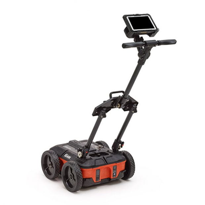
GSSI - Model UtilityScan DF -Locate and Map Underground Utilities System
UtilityScan DF incorporates our innovative dual-frequency digital antenna (300 and 800 MHz) and an easy-to-use touchscreen interface to view shallow and deep targets simultaneously in a single scan.
Most popular related searches
underground utility mapping
geological investigation
archaeology forensic
utility locating
wheeled cart
inspection system
environmental assessment
underground utility
locating underground utilities
environmental damage
-
Max Depth: 7 m (21 ft)
-
Antenna Frequency: 300/800 MHz
-
Weight: 51-66 lbs (cart dependent)
-
Storage Capacity: 128 GB
-
Optional Software: RADAN 7 for UtilityScan, RADAN 7
-
Accessories: Sunshade for Panasonic G2, LineTrac
The UtilityScan DF is typically used for:
- Utility detection
- Environmental assessment
- Damage prevention
- Geological investigation
- Archaeology
- Forensics
- Road inspection
- 300/800 MHz DF antenna
- Panasonic G2 Toughpad
- Choice of 2-wheel or 4-wheel cart
- 2 m digital control cable
- Transit case
- Lithium-ion battery (2)
- Dual-bay battery charger
- 2-year warranty