

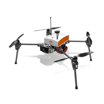
Hélicéo - Model Fox4 -Professional Multirotor Drone
The smart drone for mapping and inspection. The Fox4 is a multirotor drone with 4 carbon blades. Its light structure and engine allow for extreme maneuverability with manual piloting. Designed for automatic photogrammetry missions up to 1.5 km², Fox4 may also carry out missions for inspection of infrastructure, structures, network lines or industrial sites, in automatic or manual mode
Perfect for your daily mapping missions and calculations of cubature, this quadcopter allows for photo collages, georeferenced orthophotos and point clouds as well as DTM / DSM.
This drone is made for professionals of the measurement such as surveyors, topographers, archaeologists and responsible for quarries or mines.
Quick setup : The Fox4 is a highly functional drone that may be deployed in less than 5 min. It can scan up to 1,5km² in one flight, therefore it is ideal for small-scale surveys.
Small & portable : Weighing only 4 kg with removable blades and folding arms and feet, Fox4 is very easy to transport.
Choice of flight mode: Fox4 is simple to handle manually for inspection missions, but can also be used in automatic mode for larger scale missions.
Technical Features of Fox4 drone
The FoX 4, with its 2-axis gyroscope belly pod and 15” carbon propellers, is a multirotor drone thought and conceived for the topography world. This product is DroneBox compatible. It’s the perfect partner for photogrammetry beginners by drone and especially for survey, cubature or technical urban inspections.
- Vehicle type: multirotor drone
- Thrust : 4 blades and brushless motors
- Max takeoff weight : 5kg max
- Max payload : 0,3kg
- Battery life with load : Up to 25 Min
- Gimbal : 2-axis gyroscope
- Max speed : 50km/h (31 mph)
- Wind resistance : 50km/h (31 mph)
- Mission speed : 30km/h (18 mph)
- Control distance 2 km
- Scan surface : Up to 20 ha (49 acres)
- Safety : Parachute
- Matérial : Carbon