

- Home
- Companies
- Inertial Labs, a VIAVI Solutions ...
- Products
- Inertial-Labs RESEPI - Remote Sensing ...
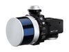
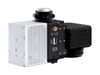
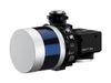
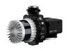

Inertial-Labs RESEPI - Remote Sensing Payload Instrument
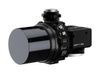
The Remote Sensing Payload Instrument - RESEPI was designed as a cost-effective solution for extremely accurate Remote Sensing applications. RESEPI utilizes a high-performance Inertial Labs GPS-Aided Inertial Navigation System (INS) with Novatel RTK/PPK single or dual antenna GNSS receiver, integrated with a Linux-based processing platform. The processing platform contains a WiFi interface, external cellular modem to support RTCM corrections, datalogging software and automated post- processing. RESEPI® can be used with commercially available LiDARs like Hesai, Velodyne, Quanergy, Ouster, RIEGL, and LIVOX. The device was built with the purpose of white-labeling.
Your Logo can be placed on all software: LIDAR calibration software. Bore-sighting software, Point Cloud Software powered by Waypoint* Inertial Explorer from Hexagon | NovAtel®, web-interfaces, and hardware. All components are mounted into one compact and light-weight enclosure and the bore-sighting and point cloud software powered by Waypoint® Inertial Explorer from Hexagon | NovAtel® is fully automated to provide optimized PPK results.
RESEPf is completely modular. You can supply the GNSS receiver. You can supply the LiDAR. We provide everything for assembling, calibrating, and bore-sighting RESEPI8. This allows you to maintain existing relationships and meet local production requirements. You have full control for customization.
RESEPl` is ALSO a complete remote sensing solution - LiDAR, all required cables, mounting brackets, vibration isolator, LiDAR Calibration, Bore-sighting, Post-Processing (PPK) and Point Cloud software utilizing the Waypoint® post-processing engine from Hexagon | NovAtel® are available upon purchase of the RESEPl. Value Added Resellers can focus on growing their business rather than developing the payload product. We will support and grow the product together to meet the market requirements with a commitment to supplying the best price/performance solution to our Business Partner.
- Weight: 0.37 kg (circular enclosure w/o LiDAR); 0.42 kg (rectangular enclosure w/o LiDAR)
- Power Consumption: 12 W (with VLP-16 LIDAR)
- Position Accuracy (GPS-Aided INS): 0.5 cm (PPK estimated) / 1 cm + 1 ppm (RTK)
- Attitude Accuracy (GPS-Aided INS): <0.01 deg Pitch & Roll; <0.05 deg Heading
- Precision (Point Cloud): 3 - 5 cm (dependent on LiDAR, taken on the same target @ 50 m AGL)
- Scanner field of View (FOV): 360 deg (depend on LiDAR selection)
- Scanner (LIDAR): VELODYNE VLP / QUANERGY / RIEGL / OUSTER / Livox / Hesai
- Inertial Navigation System: Inertial Labs INS-B-OEM; INS-D-OEM
- Type of recorded data: GNSS data for PPK; GNSS time-stamped INS & IMU data; GNSS time-stamped LiDAR scans; GNSS time-stamps for camera strobe pulses