

- Home
- Companies
- Juniper Systems, Inc.
- Products
- Juniper - Model POD - GNSS Receiver
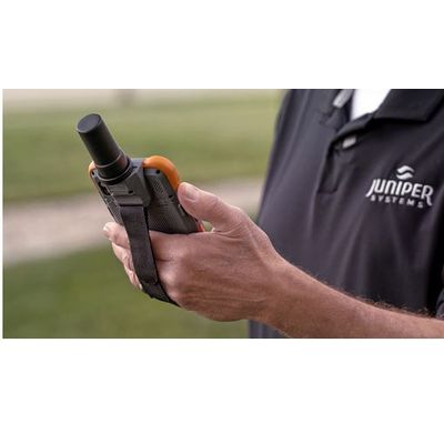
Juniper - Model POD -GNSS Receiver
Looking for greater accuracy with your Archer 4? The GNSS Expansion Pod allows you to achieve “sub-inch” centimeter-level accuracy with RTK. Using Archer Connect, our utility software, you can connect the GNSS Expansion Pod to RTK networks worldwide for when your work requires high-accuracy mapping. Simply fire up your Archer 4, launch Archer Connect, choose your corrections service, and begin mapping! The GNSS Expansion Pod is attached to the back of your Archer 4, which creates an all-in-one-hand mapping solution. One-handed operation leaves you free to move about, using your other hand to steady yourself or to operate another piece of equipment. Archer 4’s lightweight design prevents carrying fatigue while providing powerful data processing.
Knowing what you have and where it is located is essential for warehouse management. From inbound processing to shipping and distribution, the optional barcode scanner the Archer 4 Rugged Handheld makes the work go quicker. You can work more efficiently knowing the information is entered correctly the first time. You don’t have to worry about your Archer 4 dying mid-shift, simply hot-swap a charged battery and continue your work.
The Archer 4’s rugged design fits a manufacturing environment far better than a consumer tablet. Suitable for both extreme cold and extreme heat, it will maintain functionality throughout your workday. The Android 14 OS allows you to download and run the software and apps that you use every day. Learn more about manufacturing use cases on our industry page.
Rugged environments require rugged hardware. Around energy and power plants, a consumer tablet won’t cut it for water, dust, drops and extreme temperatures. The Archer 4 meets both IP68 and MIL-STD-810H standard testing for rugged devices so you know your device, and the data on it, are safe from loss.
Easily collect data for meter reading, installation and services. Map assets at the plant or out in the field. With 5G cellular connectivity, you can share your work in real time. The Archer 4 is your catch-all device to stay connected and create an uninterrupted workflow. The sleek size means that you will still have a free hand while holding the Archer 4, or that it can easily fit into a pocket when you don’t want to hold it.
A Field Service environment is really any and every environment. Technicians must be able to perform their work no matter the weather conditions or remoteness of the location. A rugged device is necessary to ensure fewer interruptions to work and to prevent loss of data due to damage or connectivity issues.
With Archer 4, technicians can stay in touch with the office using 5G cellular connectivity, run software and apps on the Android 14 operating system, and input data easily with the responsive touch screen. Take images of assets needing repair and maintenance using the camera to include in your reports. The slim design supports a more modern type of data collection including 2 programmable buttons so even your keypad is more efficient! Learn more about field service use cases on our industry page.
Location and asset mapping rely on data accuracy, efficient collection and easy shareability. Whether you are mapping company assets, wetland boundaries or underground utility lines, the Archer 4 can improve your workflow. With 5G cellular connectivity, even in the most remote locations, you can work uninterrupted. If you need more accuracy than the chipset dual-band GNSS receiver provides, you can pair the Archer 4 with a sub-meter Geode GNSS Receiver or a GNSS expansion pod to get the accuracy you need for the job.
The Archer 4 is also compatible with our Uinta Data Collection Software to help users collect and review data in customizable forms with easy cloud backup and sharing capabilities. Uinta also includes premade form templates so you can get started mapping without delay. Learn more about mapping use cases on our industry page.