

- Home
- Companies
- Spottitt Ltd.
- Products
- Land and Assets Motion Monitoring
Land and Assets Motion Monitoring
Detect early changes in land and assets movement to prevent failure risks to your critical infrastructure. Track possible land and assets motion risks on every meter of your network, at scale, Get early signals to reduce the destructive risk of land motion on your assets the integrity and performance, Make well-informed O&M decisions based on the timely and accurate analysis findings
They can cause significant damage to infrastructure assets, including ruptured or destroyed pipelines, roads, and power grids, leading to disruptions in supply and transportation and high economic costs.
Satellites help companies understand land movements, from 10 years back in the past
Conventional monitoring methods can be expensive, time-consuming, and limited by geospatial and temporal gaps. Remote sensing-based monitoring solutions overcome these limitations by providing continuous monitoring over large areas, regardless of weather or accessibility conditions.
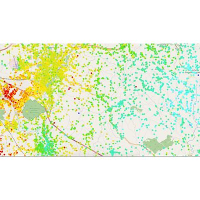
Satellite-based monitoring of land and asset movements gives asset managers a clear indication of the asset health conditions, regardless if they are overhead, such as power lines, roads and railways, or underground, such as gas, water or oil pipelines. The data is available everywhere in the world, providing land movement data back 10 years in the past, at mm/year accuracy.
Spottitt’s ground movement and asset movement monitoring solutions utilise satellite imagery and advanced machine learning algorithms to monitor targeted areas for ground surface changes that may indicate movement activity and detect any potential land movement that can cause assets damage. By alerting operators in near real-time, we help them take appropriate action to prevent potential disasters.
We provide comprehensive and frequent risk analysis using remote sensing data, which allows for detailed land- and asset movement mapping to reduce disaster risk.
Enable quick assessment of the event’s magnitude, damages, current ground situation, and its evolution, getting valuable insights to make informed decisions.
- Land displacement
- Land displacement velocity
- Asset displacement
- Asset displacement velocity
Download the brochure to learn more about Spottitt MF? for land and assets motion monitoring.
Spottitt MF allows asset managers to get accurate geospatial analytics to track all possible risks on every meter of their assets, at scale, without breaking the budget
Satellite-based analyses to avoid any hardware installation or flight permits
We automated the full process of getting satellite data and transforming them into actionable insights
View, filter and integrate our metrics the way you need, without replacing your current management systems