

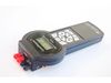
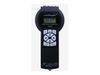

LandMapper - Model ERM-04 -Geophysical Instruments and Field Equipment
LandMapper ERM-04 is the newest device of Landviser, LLC. It can measure electrical resistivity (ER), conductivity (EC), and potential (EP).
LandMapper ERM-04 measures electrical resistivity or conductivity of soils and related media for express non-destructive mapping and monitoring of agricultural fields.
In a typical setting, a four-electrode probe is placed on the soil surface and an electrical resistivity or conductivity value is read from the digital display. The device measures electrical resistivity or conductivity in a surface soil layer of the depth from 2 cm down to 20 m.
LandMapper ERM-04 is the most versatile device in LandMapper series and allows you not only to measure ER and EC using artificially applied electrical current and four-electrode probes, but also to study natural electrical fields in soils (self-potentials) and plants (bio-potentials) with patented non-polarizing electrodes.
The electrical balance between soil and plants is important for plant health and electrical potential gradient governs water and nutrient uptake by plants. Monitoring of electrical potentials in plants and soils is a cutting-edge research topic in the leading scientific centers around the world.
- Compact – weights only 250 g without the probe.
- Fast – one measurement takes 4 sec.
- Accurate – automatically accounts for spontaneous potential arising from grounding of the electrodes.
- Safe and economical – uses a standard 9 V battery.
- Seamless connection with a personal computer for data transfer (stores 999 data values).
- Modular and interchangeable 4-electrode probes, patented non-polarizing electrodes, and detachable measuring unit.
- Versatile – the same unit can be used in field mapping and laboratory experiments.
- Affordable – compared to analogs, the prices are an order of magnitude less.
- in agriculture (to determine the fertility, productivity, moisture, texture, stone content, and salinity of soils – at multiple depths);
- in archaeology and criminology (for searching for burials, non-metallic objects);
- for treasure hunting;
- to search for underground water (even to determine its direction);
- in civil engineering, etc.
– all of the above – without digging and collecting soil samples, directly from the ground surface, down to 20-30 meters!