

- Home
- Companies
- Lang Tool Co.
- Products
- LTC - GPS Program
LTC - GPS Program
When the horizontal and vertical limits of a soil mixing project are established, Lang Tool Co. prepares a CAD drawing of the cell layout for the project and a surface drawing that conforms to the bottom mixing elevation or target. The bottom surface can vary if the project specifications call for different target elevations on various parts of the mixing area. LTC used these files to create a GPS program for the project.
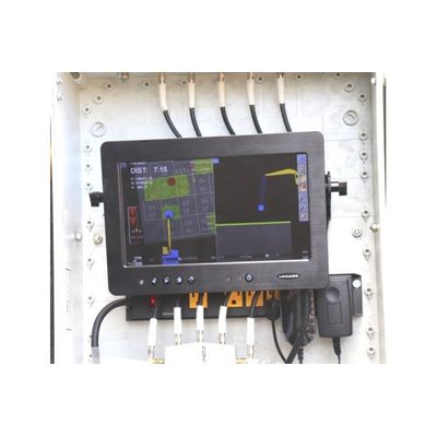
When the GPS program is loaded into the Dual Axis Blender computer the operator sees the cell layout, the cell designation, the machine and the blender head. “DIST” is the distance to the bottom mixing elevation or the target. The cross-sectional view on the right of the GPS screen shows the mixing progress toward the target. This screen is broadcast to the reagent plant operator so he has real-time information on the mixing progress, which allows him to match the rate of reagent delivery to the mixing rate of the blender. The screen in the photo is the screen on one of the reagent plants. The screen turns green when the blender is between 0.5’ above the target and the target. The screen turns yellow when mixing is between the target and 0.5’ below the target. When mixing is deeper than 0.5’ below the target, the screen turns red.