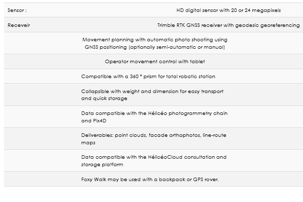
FoxyWalk - Mobile Mapping System
FoxyWalk is a platform for professional acquisition of terrestrial photogrammetry in pedestrian mode. It is aimed towards surveyors, topographers, architects, archaeologists. It allows the shooting of photos which would be inaccessible from the sky (facades, arches, etc.) and creation of 3D models.
Terrestrial photogrammetry allows the survey of the shape and dimensions of inaccessible objects, study of deformations and analysis of structural anomalies. It may also be used in determining volumes.
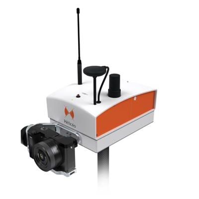
Practicality : The FoxyWalk carries the DroneBox RTK and is usable in backpack mode or with a GNSS rover. It is collapsible, with weight and dimensions for easy transport and quick storage. The FoxyWalk is also compatible with a 360 ° prism for total robotic station.
Data accuracy : Thanks to DroneBox RTK and a 20 to 24 megapixel HD sensor, each photo may be georeferenced with precision and a high density acquisition of several million points may be achieved.
Rapid acquisition : Survey your sites 3 times faster than a conventional GPS rover thanks to movement planning with automatic photo shooting using GNSS positioning (optionally semi-automatic or manual).
Terrestrial photogrammetry applications are varied :Reconstruction of facades, heritage conservation, monitoring structures and sites as well as
supplementing aerial surveys and surveys of routes, ditches and open trenches with georeferencing networks (DT-DICT).