

- Home
- Companies
- Satellite Imaging Corporation
- Products
- Model WorldView-4 - Satellite Sensor
Model WorldView-4 -Satellite Sensor
On January 7, 2019, Maxar Technologies Inc. reported that its WorldView-4 satellite experienced a failure in its control moment gyros ("CMGs"), preventing the satellite from collecting imagery due to the loss of an axis of stability. Efforts are ongoing in conjunction with its suppliers in an attempt to restore satellite functionality, but thus far these efforts have been unsuccessful. At this time, Maxar believes that WorldView-4 will likely not be recoverable and will no longer produce usable imagery. Maxar operations have put the WorldView-4 satellite in a safe configuration and will continue to monitor the satellite`s location and health. The satellite was built by Lockheed Martin and the CMGs were provided by Honeywell.
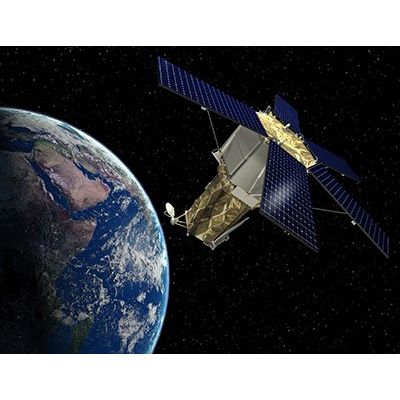
WorldView-4 satellite was successfully launched on Friday, November 11, 2016, at 10:30 a.m. PST from Vandenberg Air Force Base, California. MAXAR`s WorldView-4 is capable of discerning objects on the Earth`s surface as small as 31cm in the panchromatic and will collect 4-band multispectral at 1.24-meter resolution. WorldView-4 will have a similar resolution as the WorldView-3 satellite sensor. This advanced resolution will offer customers unprecedented, precise views for 2D or 3D mapping, change detection, and image analysis.
WorldView-4 satellite offers exceptional geolocation accuracy, which means that customers will be able to map natural and man-made features to better than <4 meter CE90 of their actual location on the Earth’s surface without ground control points.
WorldView-4 will be flying at an altitude of 617 km (383 miles) and will be able to “revisit” any point on the globe every 4.5 days or sooner, depending upon the required look angle. The altitude could be revised before launch to utilize the recently obtained permission to acquire and deliver 0.25m resolution imagery.
WorldView-4 customers will have a choice of ordering BASIC (satellite projection), Geo (geometrically corrected), GeoProfessional (terrain corrected or ortho-rectified), or GeoStereo (stereo pair) products, as well as imagery-derived products, including digital elevation models (DEMs), digital surface models (DSMs), large-area mosaics, and feature maps.
MAXAR`s Atmospheric Compensation (AComp) an algorithm that removes haze and vapor particles and is used to correct and clarify high resolution panchromatic and multi-spectral satellite images (including SWIR bands) under diverse atmospheric conditions. Read more on Atmospheric Compensation - MAXAR AComp Pre-Processing