

- Home
- Companies
- Nanjing Movelaser Co., Ltd.
- Products
- MOVELASER - Model Molas 3D - 1kW 3500m ...
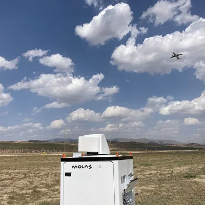
MOVELASER - Model Molas 3D -1kW 3500m Altitude Doppler Wind Lidar 5-18 Months Data Storage
The 1kW 3500m Altitude Doppler Wind Lidar is an advanced system designed for comprehensive wind measurement. This high-precision lidar utilizes a 1kW laser to measure wind at altitudes up to 3500 meters, with a data storage capacity ranging from 5 to 18 months. Incorporating Plan Position Indicator (PPI) scanning methods, the system's radar antenna accurately displays distance and echo strength based on constant pitch angles and variable azimuth angles, suitable for applications in air traffic control, ship navigation, and meteorology. Key parameters include environmental adaptability at -25 to +50°C, extendable to -40 to +60°C, and a protection class of IP67 for the complete machine. Furthermore, the lidar integrates GPS and Beidou systems for enhanced positioning. Designed to meet rigorous performance standards, this lidar offers reliability and precision in challenging conditions, with scanning capabilities including PPI, RHI, DBS, LOS, and programmable options. Connectivity options include 1000BASE-TX or 4G remote access, ensuring real-time data transfer and robust telecommunication capabilities.Survival Wind Speed: 70m/s (fixed By Foot Or By Wire Rope)
Working Altitude: ≤3500m
Running Power Consumption: ≤1kW
Powered By: 110VAC±20% Or 220VAC±20%, 50Hz±10%
Size: 800mm*650mm*11 30mm
High Light: 3500m Altitude Doppler Wind Lidar, 1kW Doppler Wind Lidar, PPI scan lidar wind measurement
The full name of PPI is Plan Position Indicator. The center point is the radar antenna. The radar antenna displays the distance and echo strength of the target object when the pitch angle is constant, and the azimuth angle scans a circle or a specific angle. Commonly used in various radar displays in the fields of air traffic control, ship navigation, and meteorology.
Basic parameters
Line-of-sight detection distance: 10km (typical case)
Distance resolution: 30m/45m/60m/75m optional
Accumulation time: 0.5s/1s/2s/4s/8s optional
Radial wind speed measurement range: -75~+75 m/s
Radial wind speed measurement accuracy: 0.1m/s
Number of distance layers: up to 300
Horizontal scan range: 360° × n
Vertical scan range: -10°~190°
Pointing accuracy: 0.1°
Scanning method: PPI , RHI , DBS , LOS and Program Scan
Real-time data output form: Profibus DP/Modbus TCP/CAN optional
Telecommunication: 1000BASE-TX or 4G remote access
Environmental parameters
Operating temperature and humidity: -25~+50℃ (extendable to -40~+60℃),
5%~100% RH
IP protection class: Housing IP54, core module IP66
Anticorrosion grade: C4
Survival wind speed: 70m/s (fixed by foot or by wire rope)
Working altitude: ≤3500m
Other parameters
Running power consumption: ≤1kW
Powered by: 110VAC±20% or 220VAC±20%,
50Hz±10%
Size: 800mm*650mm*11
30mm
Weight: ≤150kg
Accessibility
GNSS functionality: Support GPS/Beidou
Time service: NTP timing or GPS/Beidou timing