- Home
- Companies
- WTS Geophysical Solutions
- Products
- WTS - Model ADMT Series - Multi Channel ...
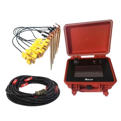
WTS - Model ADMT Series -Multi Channel Water Detector
The new generation of ADMT-Multi-Channel series constantly updates the hardware and software, and pushes the boundaries by introducing features previously unseen in commercial resistivity meters. The latest upgrade of new resistivity measurement features using natural electric fields results in increased measuring speed and improved data quality. Resistivity surveying is a versatile geophysical method suitable for various applications and environments such as groundwater prospecting, mineral exploration, geological mapping, and geotechnical investigations. System design can vary depending on the application. It is available in many different configurations to perfectly match your requirements. It introduces an APP data process system. The whole measurement can be controlled by a mobile phone (which supports the Android system), making the operation more convenient and faster to get the result.
- Geotechnical pre-investigation
- Groundwater prospecting
- Mineral exploration
- Geothermal prospecting
- Archaeology
- Stable field source: It solves the shortcomings of inconsistent field source of natural field instruments, and the consistency of repeated measurement profiles is good.
- Small movement error: There is an electrode movement error when solving multiple movement measurement and the profile measurement is completed in one line.
- Reliable data: It is convenient to measure and compare multiple times, which greatly reduces the interference error and improves the data accuracy.
- It is used to find detailed information such as the direction, depth and water output of ground water (geothermal hot spring), which greatly improves the success rate of well drillings.
- For detailed investigation and census of regional hydrogeology such as environmental investigation, engineering exploration, geothermal exploration and geological disasters.
- Automatically from geological graph: operating by mobile phone and all the date can be immediately calculated after the measure done.
- Wireless measure: Using wireless sensor to complete the measure just by stop-and–go.
- Free USB disk: Data is transmitted in your mobile phone then you can upload to the cloud or pc or permanent storage.